| Congresbury | |
|---|---|
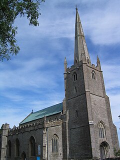
 St Andrew's Church, Congresbury | |
Location within Somerset | |
| Population | 3,497 (2011)[1] |
| OS grid reference | ST435635 |
| Unitary authority | |
| Ceremonial county | |
| Region | |
| Country | England |
| Sovereign state | United Kingdom |
| Post town | Bristol |
| Postcode district | BS49 |
| Dialling code | 01934 |
| Police | Avon and Somerset |
| Fire | Avon |
| Ambulance | South Western |
| UK Parliament | |
Congresbury is a village and civil parish on the northwestern slopes of the Mendip Hills in North Somerset, England, which in 2011 had a population of 3,497.[1] It lies on the A370 between Junction 21 of the M5 and Bristol Airport, 13 miles (21 km) south of Bristol city centre, and 7 miles (11 km) east of Weston-super-Mare. The Congresbury Yeo river flows through the village. The parish includes the hamlet of Brinsea.
The nearest railway station is Yatton, with trains provided by Great Western Railway, but Congresbury once had its own railway station on the Cheddar Valley Line from Yatton to Wells. It was also the starting point for the Wrington Vale Light Railway, which went to nearby Wrington and Blagdon.
- ^ a b "2011 Census Profile". North Somerset Council. Archived from the original (Excel) on 4 January 2014. Retrieved 4 January 2014.
