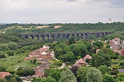
Conisbrough Viaduct | |
|---|---|
 Conisbrough Viaduct looking eastwards | |
| Coordinates | 53°29′17″N 1°12′36″W / 53.488°N 1.210°W |
| OS grid reference | SK524993 |
| Carries | Public path |
| Crosses | River Don |
| Locale | Conisbrough, South Yorkshire, England |
| Characteristics | |
| Material | Red brick |
| Trough construction | Blue brick |
| Pier construction | Steel |
| Total length | 1,527 feet (465 m) |
| Height | 113–116 feet (34–35 m)[note 1] |
| No. of spans | 22 (21 arches) |
| Rail characteristics | |
| No. of tracks | 1 |
| Track gauge | 4 ft 8+1⁄2 in (1,435 mm) standard gauge |
| History | |
| Fabrication by | Gates & Hogg |
| Construction start | 1906 |
| Construction end | 1909 |
| Construction cost | £4,919 (1906) |
| Opened | 17 March 1909 |
| Closed | 31 July 1966 |
| Statistics | |
| Daily traffic | Heavy rail |
Listed Building – Grade II | |
| Designated | 1 July 2021 |
| Reference no. | 1475175 |
| Location | |
 | |
Conisbrough Viaduct is a former railway viaduct, near to Cadeby and Conisbrough in South Yorkshire, England. The viaduct consists of two sections of brick and stone on each bank, connected by a lattice girder section, some 113–116 feet (34–35 m) over the River Don. The height and space were required should shipping need to navigate along the river. The viaduct carried the Dearne Valley Railway over the River Don between 1909 and 1966, after closure it was converted into a foot and cycle path. The structure is grade II listed, and is notable for being one of the first bridges in Britain to be built using a rope system above the viaduct known as a "Blondin".
The viaduct was 4.5 miles (7.2 km) west of Edlington Halt, and 17 miles (27 km) south of Crofton Junction.
Cite error: There are <ref group=note> tags on this page, but the references will not show without a {{reflist|group=note}} template (see the help page).