| Continental Divide Trail | |
|---|---|
 | |
| Length | 3,028 mi (4,873 km) |
| Location | United States |
| Designation | National Scenic Trail in 1978 |
| Trailheads | Northern: Waterton Lakes National Park, Alberta, Glacier National Park, Montana at the U.S.–Canada border Southern: Crazy Cook Monument, Big Hatchet Mountains, New Mexico at the U.S.–Mexico border |
| Use | Hiking some Horseback riding some Mountain biking |
| Highest point | Grays Peak, Colorado, 14,278 ft (4,352 m) |
| Lowest point | Lordsburg, New Mexico and Waterton Lakes, Alberta, 4,200 ft (1,300 m) |
| Months | April to October |
| Sights | Continental Divide |
| Hazards | Avalanches Black bears Dehydration Falling Grizzly bears Hypothermia Landslides Lightning Mountain lions Severe weather Snow |

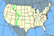
The Continental Divide National Scenic Trail (in short Continental Divide Trail, CDT) is a United States National Scenic Trail with a length measured by the Continental Divide Trail Coalition of 3,028 miles (4,873 km) between the U.S. border with Chihuahua, Mexico and the border with Alberta, Canada.[1] Frequent route changes and a large number of alternate routes result in an actual hiking distance of 2,700 miles (4,300 km) to 3,150 miles (5,070 km).[2] The CDT follows the Continental Divide of the Americas along the Rocky Mountains and traverses five U.S. states — Montana, Idaho, Wyoming, Colorado, and New Mexico. In Montana near the Canadian border the trail crosses Triple Divide Pass (near Triple Divide Peak, from which waters may flow to either the Arctic Ocean (via Hudson Bay), Atlantic Ocean or Pacific Ocean).
In 2021, the CDT was about 70 percent complete, with a combination of dedicated trails and dirt and paved roads. Hikers can continue north into Alberta and British Columbia via the Great Divide Trail to Kakwa Lake in Kakwa Provincial Park and Protected Area, B.C., north of Jasper National Park.
The CDT was described in 2013 by a Triple Crown hiker as "Raw, wild, remote and unfinished; it is a trail that will make use of all the skills of an experienced backpacker. It is also a trail that is beautiful, stunning and perhaps the most rewarding of the major long-distance hiking trails."[2] Distances given are approximate as sections of the trail are uncompleted and the trail is sometimes re-routed.
- ^ "CDT Interactive Map". Continental Divide Trail Coalition.
- ^ a b "A Quick and Dirty Guide to the Continental Divide Trail". PMags. 17 December 2013. Retrieved 20 February 2021.