Cooke County | |
|---|---|
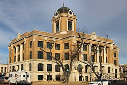
 The Cooke County Courthouse in Gainesville | |
 Location within the U.S. state of Texas | |
 Texas's location within the U.S. | |
| Coordinates: 33°38′00″N 97°13′00″W / 33.633333333333°N 97.216666666667°W | |
| Country | |
| State | |
| Founded | 1849 |
| Seat | Gainesville |
| Largest city | Gainesville |
| Area | |
• Total | 898 sq mi (2,330 km2) |
| • Land | 875 sq mi (2,270 km2) |
| • Water | 24 sq mi (60 km2) 2.6% |
| Population (2020) | |
• Total | 41,668 |
| • Density | 46/sq mi (18/km2) |
| Time zone | UTC−6 (Central) |
| • Summer (DST) | UTC−5 (CDT) |
| Congressional district | 26th |
| Website | www |
Cooke County is a county in the U.S. state of Texas. At the 2020 census, its population was 41,668.[1][2] The county seat is Gainesville.[3] The county was founded in 1848 and organized the next year. It is named for William Gordon Cooke, a soldier during the Texas Revolution. It is a part of the Texoma region.
Cooke County comprises the Gainesville, TX micropolitan statistical area, which is also included in the Dallas–Fort Worth, TX-OK combined statistical area.
- ^ "U.S. Census Bureau QuickFacts: Cooke County, Texas". United States Census Bureau. Retrieved January 31, 2022.
- ^ "Cooke County, Texas". United States Census Bureau. Retrieved February 23, 2021.
- ^ "Find a County". National Association of Counties. Archived from the original on May 31, 2011. Retrieved June 7, 2011.
