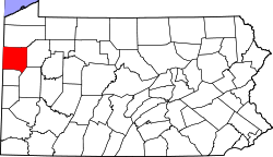
Coolspring Township, Mercer County, Pennsylvania | |
|---|---|
 Township building | |
 Location of Coolspring Township in Mercer County | |
 Location of Mercer County in Pennsylvania | |
| Country | United States |
| State | Pennsylvania |
| County | Mercer |
| Area | |
• Total | 19.09 sq mi (49.45 km2) |
| • Land | 18.77 sq mi (48.62 km2) |
| • Water | 0.32 sq mi (0.83 km2) |
| Highest elevation [2] (Rodgers Point at northwestern end of township) | 1,360 ft (410 m) |
| Lowest elevation [2] (Otter Creek) | 1,095 ft (334 m) |
| Population | |
• Total | 2,113 |
• Estimate (2023)[3] | 2,081 |
| • Density | 118.42/sq mi (45.72/km2) |
| Time zone | UTC-4 (EST) |
| • Summer (DST) | UTC-5 (EDT) |
| Area code | 724 |
Coolspring Township is a township in Mercer County, Pennsylvania, United States. The population was 2,112 at the 2020 census,[4] a decline from the figure of 2,278 in 2010.[5]
- ^ "2016 U.S. Gazetteer Files". United States Census Bureau. Retrieved Aug 14, 2017.
- ^ a b "Fredonia Topo Map, Mercer County PA (Fredonia Area)". TopoZone. Locality, LLC. Retrieved 7 September 2019.
- ^ a b Bureau, US Census. "City and Town Population Totals: 2020-2023". Census.gov. US Census Bureau. Retrieved July 1, 2024.
{{cite web}}:|last1=has generic name (help) - ^ Bureau, US Census. "City and Town Population Totals: 2020-2021". Census.gov. US Census Bureau. Retrieved 26 June 2022.
{{cite web}}:|last1=has generic name (help) - ^ "U.S. Census website". United States Census Bureau. Retrieved 2017-03-05.