| Cooma New South Wales | |||||||||||||||
|---|---|---|---|---|---|---|---|---|---|---|---|---|---|---|---|
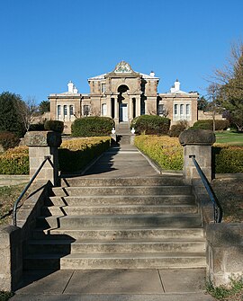
 Cooma Court House | |||||||||||||||
| Coordinates | 36°14′06″S 149°07′33″E / 36.23500°S 149.12583°E | ||||||||||||||
| Population | 6,715 (SAL 2021)[1] | ||||||||||||||
| Established | 1849 | ||||||||||||||
| Postcode(s) | 2630 | ||||||||||||||
| Elevation | 800 m (2,625 ft) | ||||||||||||||
| Location | |||||||||||||||
| LGA(s) | Snowy Monaro Regional Council | ||||||||||||||
| County | Beresford | ||||||||||||||
| State electorate(s) | Monaro | ||||||||||||||
| Federal division(s) | Eden-Monaro | ||||||||||||||
| |||||||||||||||
| |||||||||||||||
Cooma is a town in the south of New South Wales, Australia. It is located 114 kilometres (71 mi) south of the national capital, Canberra, via the Monaro Highway. It is also on the Snowy Mountains Highway, connecting Bega with the Riverina.
At the 2021 census, Cooma had a population of 6,715.[2] Cooma is the main town of the Monaro region. It is 800 metres (2,620 ft) above sea level. The name could have derived from an Aboriginal word Coombah, meaning 'big lake' or 'open country'.[3]
Cooma is 5 kilometres (3 mi) south of the banks of the Murrumbidgee River, a main tributary of the Murray–Darling basin. Cooma sources its water from the river.
- ^ Australian Bureau of Statistics (28 June 2022). "Cooma (NSW) (suburb and locality)". Australian Census 2021 QuickStats. Retrieved 28 June 2022.
- ^ Cite error: The named reference
Censuswas invoked but never defined (see the help page). - ^ "Cooma". Geographical Names Register (GNR) of NSW. Geographical Names Board of New South Wales. Retrieved 12 July 2009.
