| Coomera | |
|---|---|
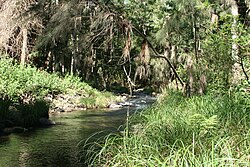
 Upper reaches of the Coomera River in Lamington National Park | |
Location of Coomera River river mouth in Queensland | |
| Etymology | Aboriginal word kumera |
| Location | |
| Country | Australia |
| State | Queensland |
| Region | South East Queensland |
| Local government areas | Scenic Rim Region, City of Gold Coast |
| Physical characteristics | |
| Source | McPherson Range, Great Dividing Range |
| • location | Binna Burra |
| • coordinates | 28°13′3″S 153°11′9″E / 28.21750°S 153.18583°E |
| • elevation | 524 m (1,719 ft) |
| Mouth | Gold Coast Broadwater |
• location | Coomera (north branch), Paradise Point (south branch) |
• coordinates | 27°51′58″S 153°24′21″E / 27.86611°S 153.40583°E |
• elevation | 0 m (0 ft) |
| Length | 80 km (50 mi) |
| Basin size | 489 km2 (189 sq mi) |
| Basin features | |
| Tributaries | |
| • left | Guanaba Creek, Wongawallan Creek, Baker Creek (Queensland), Bygon Creek, Yuan Creek, Oakey Creek (Queensland), Coomera River (North Branch) |
| • right | Back Creek (Queensland), Price Creek (Queensland), Saltwater Creek (Gold Coast, Queensland), Coombabah Creek |
| National park | Lamington National Park |
| [1][2] | |
The Coomera River is a perennial river in the South East region of Queensland, Australia. Its catchment lies within the Gold Coast and Scenic Rim Region local government areas and covers an area of 489 square kilometres (189 sq mi).[3]
- ^ "Map of Coomera River, QLD". Bonzle Digital Atlas of Australia. Retrieved 27 September 2015.
- ^ "Coomera River Catchment". City of Gold Coast. Retrieved 27 September 2015.
- ^ Cite error: The named reference
qpnwas invoked but never defined (see the help page).
