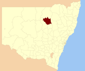
| Coonamble Shire New South Wales | |||||||||||||||
|---|---|---|---|---|---|---|---|---|---|---|---|---|---|---|---|
 Location in New South Wales | |||||||||||||||
| Coordinates | 30°57′S 148°24′E / 30.950°S 148.400°E | ||||||||||||||
| Population | 3,732 (2021 census)[1] | ||||||||||||||
| • Density | 0.37598/km2 (0.97379/sq mi) | ||||||||||||||
| Established | 1 May 1952[2] | ||||||||||||||
| Area | 9,926 km2 (3,832.5 sq mi) | ||||||||||||||
| Mayor | Daniel Keady (Independent) | ||||||||||||||
| Council seat | Coonamble | ||||||||||||||
| Region | Orana | ||||||||||||||
| State electorate(s) | Barwon | ||||||||||||||
| Federal division(s) | Parkes | ||||||||||||||
 | |||||||||||||||
| Website | Coonamble Shire | ||||||||||||||
| |||||||||||||||
Coonamble Shire is a local government area in the Orana region of New South Wales, Australia. The Shire is located adjacent to the Castlereagh Highway and the Castlereagh River.
Coonamble Shire includes the towns of Coonamble, Gulargambone and Quambone.
The mayor of Coonamble Shire Council is Cr. Daniel Keady.[3]
- ^ Australian Bureau of Statistics (28 June 2022). "Coonamble (A)". 2021 Census QuickStats. Retrieved 21 October 2024.
- ^ Cite error: The named reference
estwas invoked but never defined (see the help page). - ^ "Councillors - Coonamble Shire Council". coonambleshire.nsw.gov.au. 1 October 2024. Retrieved 22 October 2024.