| Coos River | |
|---|---|
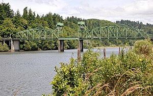
 Coos River at the Chandler Bridge | |
| Etymology | Indian name for a native tribe living near Coos Bay[2] |
| Location | |
| Country | United States |
| State | Oregon |
| County | Coos |
| Physical characteristics | |
| Source | Confluence of Millicoma River and South Fork Coos River |
| • location | Coos County, Oregon |
| • coordinates | 43°22′39″N 124°05′57″W / 43.37750°N 124.09917°W[1] |
| • elevation | 13 ft (4.0 m)[3] |
| Mouth | Coos Bay |
• location | Coos Bay, Coos County, Oregon |
• coordinates | 43°21′45″N 124°10′25″W / 43.36250°N 124.17361°W[1] |
• elevation | 0 ft (0 m)[1] |
| Length | 5 mi (8.0 km)[4] |
| Basin size | 730 sq mi (1,900 km2)[5] |
| Discharge | |
| • average | 1,441 cu ft/s (40.8 m3/s)[6] |
The Coos River flows for about 5 miles (8.0 km) into Coos Bay along the Pacific coast of southwest Oregon in the United States.[4] Formed by the confluence of its major tributaries, the South Fork Coos River and the Millicoma River, it drains an important timber-producing region of the Southern Oregon Coast Range.[5] The course of the main stem and the major tributaries is generally westward from the coastal forests to the eastern end of Coos Bay near the city of Coos Bay.[7]
The river is the largest tributary of Coos Bay, which at about 10,000 acres (4,000 ha) is the largest estuary that lies entirely within Oregon.[5] The river enters the bay about 15 miles (24 km)[5] from where the bay—curving east, north, and west of the cities of Coos Bay and North Bend and passing by the communities of Barview and Charleston—meets the ocean.[7] About 30 other tributaries also enter the bay directly.[5]
Most of the Coos River watershed of 730 square miles (1,900 km2) is in Coos County, but 147 square miles (380 km2) are in eastern Douglas County.[5] Commercial forests cover about 85 percent of the basin.[5]
The river supports populations of chinook and coho salmon, Pacific lamprey,[8] western brook lamprey,[8] shad, steelhead, and coastal cutthroat trout. Since public river-bank access is limited, fishing is often done by boat.[9]
- ^ a b c "Coos River". Geographic Names Information System. United States Geological Survey. November 28, 1980. Retrieved April 1, 2011.
- ^ McArthur, p. 228
- ^ "South Fork Coos River". Geographic Names Information System. United States Geological Survey, United States Department of the Interior. Retrieved 2008-11-13.
- ^ a b United States Geological Survey. "United States Geological Survey Topographic Map". TopoQuest. Retrieved April 1, 2011. The Allegany quadrangle of the map includes river mile (RM) markers for the river's entire length.
- ^ a b c d e f g Oregon Department of Fish and Wildlife; Citizen Advisory Committee (1990). "Coos River Basin Fish Management Plan" (PDF). University of Oregon. p. 7. Retrieved April 1, 2011.
- ^ Palmer, Tim (2014). Field Guide to Oregon Rivers. Corvallis: Oregon State University Press. pp. 106–08. ISBN 978-0-87071-627-0.
- ^ a b Oregon Atlas and Gazetteer (Map) (1991 ed.). DeLorme Mapping. § 33–34. ISBN 978-0-89933-347-2.
- ^ a b Larsen, Erik. Lamprey in the Coos Estuary. Partnership for Coastal Watersheds, 23 Apr. 2014, www.partnershipforcoastalwatersheds.org/wordpress/wp-content/uploads/2015/10/FINAL-Lamprey-Data-Summary-03122014.pdf. Pamphlet.
- ^ Sheehan, pp. 66–67
