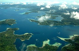
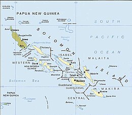
 Aerial view of Solomon Islands | |
 | |
| Geography | |
|---|---|
| Location | Pacific Ocean |
| Coordinates | 9°28′S 159°49′E / 9.467°S 159.817°E |
| Archipelago | Solomon Islands archipelago |
| Total islands | 6 main islands and more than 986 smaller islands |
| Major islands | Choiseul, the New Georgia Islands, Santa Isabel, Malaita, Makira (San Cristobal), Guadalcanal. |
| Administration | |


The Coral reefs of the Solomon Islands consists of six major islands and over 986 smaller islands,[1] in Oceania, to the east of Papua New Guinea and northwest of Vanuatu. The Solomon Islands lie between latitudes 5° and 13°S, and longitudes 155° and 169°E. The distance between the westernmost and easternmost islands is about 1,500 km (930 mi). The Santa Cruz Islands are situated north of Vanuatu and are especially isolated at more than 200 km (120 mi) from the other islands. The Solomon Islands (the Solomons) has the 22nd largest Exclusive Economic Zone of 1,589,477 km2 (613,701 sq mi) of the Pacific Ocean.
The Solomons has a rich and diverse marine life, including coral reefs and seagrass meadows. The islands are part of the Coral Triangle, the region of the western Pacific with the World's greatest diversity of corals and coral reef species. The recognizable reef systems in the Solomons are: fringing reef, patch reef, barrier reef, atoll reefs and lagoon environment.[1] The baseline survey of marine biodiversity in 2004,[2][3] identified the Solomons as having the second highest diversity of corals in the World, second only to the Raja Ampat Islands in eastern Indonesia.[4]
The Coral reefs of the Solomons make up nearly 6,750 km2 (2,610 sq mi) of total coral reef area.[5] There are 113 Locally Managed Marine Areas (LMMA) containing an estimated 155 no-take zones in the Solomons. The largest LMMA, with a contiguous 13 km (10 mi) no-take zone, is on Tetepare Island.[6]
More than 90% of inshore coastal areas, reefs and islets in the Solomons are owned and managed under the customary marine tenure system, under which family units, clans, or tribes have rights to access and use marine resources. This kinship group ownership system is recognised under the Solomon Islands Constitution.[7] The methods of management of marine resources under the customary marine tenure system include limited entry, closed seasons, closed areas, size limits, species prohibitions and restrictions on the use of fishing equipment.[7] The success or failure of conservation efforts on coral reefs largely depends on the attitudes of the communities owning them.[8]
- ^ a b Kool, J., T. Brewer, M. Mills, and R. Pressey. (2010). Ridges to Reefs Conservation Plan for Solomon Islands (Report). Townsville: ARC Centre of Excellence for Coral Reef Studies. Retrieved 31 March 2021.
{{cite report}}: CS1 maint: multiple names: authors list (link) - ^ Turak, E. edited by Green, A., P. Lokani, W. Atu, P. Ramohia, P. Thomas and J. Almany (2006). Solomon Islands Marine Assessment: Technical report of survey conducted May 13 to June 17, 2004. TNC Pacific Island Countries Report No. 1/06 (PDF) (Report). DC: World Resources Institute. pp. 65–109. Retrieved 31 March 2021.
{{cite report}}:|author=has generic name (help)CS1 maint: multiple names: authors list (link) - ^ Veron, J. E. N., and E. Turak, edited by Green, A., P. Lokani, W. Atu, P. Ramohia, P. Thomas and J. Almany (2006). Solomon Islands Marine Assessment: Technical report of survey conducted May 13 to June 17, 2004. TNC Pacific Island Countries Report No. 1/06 (PDF) (Report). DC: World Resources Institute. Retrieved 31 March 2021.
{{cite report}}:|author=has generic name (help)CS1 maint: multiple names: authors list (link) - ^ Doubilet, David. "Ultra Marine: In far eastern Indonesia, the Raja Ampat islands embrace a phenomenal coral wilderness". National Geographic, September 2007. Archived from the original on 2008-04-09. Retrieved 20 August 2023.
- ^ Burke, L., Reytar, K., Spalding, M., Perry, A., Knight, M., Kushner, B., Starkhouse, B., Waite, R. and White, A. (2012). Reefs at Risk Revisited in the Coral Triangle (PDF) (Report). DC: World Resources Institute. Retrieved 31 March 2021.
{{cite report}}: CS1 maint: multiple names: authors list (link) - ^ Denley D., Metaxas A., Scheibling R. (2020). "Subregional variation in cover and diversity of hard coral (Scleractinia) in the Western Province, Solomon Islands following an unprecedented global bleaching event". PLOS ONE. 15 (11): e0242153. Bibcode:2020PLoSO..1542153D. doi:10.1371/journal.pone.0242153. PMC 7657522. PMID 33175873.
{{cite journal}}: CS1 maint: multiple names: authors list (link) - ^ a b Sulu R., Boso, D., Vave-Karamui A., Mauli S. (2014). State of the Coral Triangle: Solomon Islands (Report). Asian Development Bank. doi:10.13140/RG.2.1.1991.7280. Retrieved 31 March 2021.
{{cite report}}: CS1 maint: multiple names: authors list (link) - ^ Sulu, Reuben & C., Hay & Ramohia, P. & Lam, M. (2003). The status of Solomon Islands coral reefs (Report). Centre IRD de Nouméa. Retrieved 31 March 2021.
{{cite report}}: CS1 maint: multiple names: authors list (link)