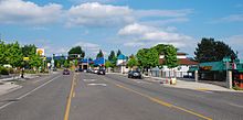
 Cornell Road in Cedar Mill | |
| Length | 14.7 mi (23.7 km) |
|---|---|
| East end | NW Lovejoy Street in Portland |
| Major junctions | Murray Blvd in Washington County NW 185th Avenue in Hillsboro Cornelius Pass Road in Hillsboro Brookwood Parkway in Hillsboro |
| West end | E Main Street in Hillsboro |

Cornell Road is an east–west street and traffic corridor in the Portland metropolitan area, in Multnomah and Washington counties in the U.S. state of Oregon. It crosses the Tualatin Mountains (West Hills) between the Willamette Valley and the city of Portland on the east and the Tualatin Valley and the city of Hillsboro on the west.[1]
Cornell Road runs between the western end of Northwest Lovejoy Street in the Hillside neighborhood of Portland to East Main Street in Hillsboro, passing through unincorporated parts of Washington County and through Beaverton on the way. On the west side of NW 185th Ave, it is called Northeast Cornell Road,[2] as it runs through the northeast quadrant of Hillsboro.
Although intended, on its section within the city of Portland, to be a neighborhood collector street with relatively low traffic volumes, it has often functioned as a major traffic street and commuter highway between downtown Portland and its western suburbs. It shares this role with more intensely busy traffic corridors along West Burnside Street and U.S. Route 26 (US 26).[3] The road has at least two lanes in each direction the entire length while south of US 26, while those portions north of US 26 are largely one-lane in each direction.
- ^ "Northwest Cornell Road, Portland, Oregon" (Map). Google Maps. Retrieved October 14, 2015.
- ^ Base Maphillsboro-oregon.gov Archived 2017-07-10 at the Wayback Machine
- ^ Portland Bureau of Transportation (1996). "NW Cornell Road – Lovejoy to Tunnel". City of Portland. Archived from the original on March 5, 2016. Retrieved September 13, 2019.