Corona de Tucson, Arizona | |
|---|---|
 Corona de Tucson and Santa Rita foothills | |
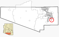
 Location in Pima County and the state of Arizona | |
| Coordinates: 31°57′28″N 110°46′2″W / 31.95778°N 110.76722°W | |
| Country | |
| State | |
| County | Pima |
| Area | |
| • Total | 7.68 sq mi (19.90 km2) |
| • Land | 7.68 sq mi (19.90 km2) |
| • Water | 0.00 sq mi (0.00 km2) |
| Elevation | 3,281 ft (1,000 m) |
| Population (2020) | |
| • Total | 9,240 |
| • Density | 1,202.81/sq mi (464.39/km2) |
| Time zone | UTC-7 (MST (no DST)) |
| ZIP code | 85641 |
| Area code | 520 |
| FIPS code | 04-16030 |
| GNIS feature ID | 37250 |

Corona de Tucson is a census-designated place (CDP) in Pima County, Arizona, United States. The population was 9,240 at the 2020 census, an increase of 1036% from the 2000 population of 813.
- ^ "2020 U.S. Gazetteer Files". United States Census Bureau. Retrieved October 29, 2021.

