| Corowa Shire New South Wales | |||||||||||||||
|---|---|---|---|---|---|---|---|---|---|---|---|---|---|---|---|
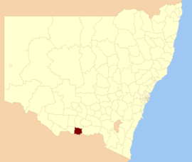
 Location in New South Wales | |||||||||||||||
| Coordinates | 35°59′S 146°23′E / 35.983°S 146.383°E | ||||||||||||||
| Population | 11,383 (2012)[1] | ||||||||||||||
| • Density | 4.8875/km2 (12.659/sq mi) | ||||||||||||||
| Established | 1955 | ||||||||||||||
| Abolished | 2016 | ||||||||||||||
| Area | 2,329 km2 (899.2 sq mi) | ||||||||||||||
| Council seat | Corowa[2] | ||||||||||||||
| Region | Riverina | ||||||||||||||
| State electorate(s) | Albury | ||||||||||||||
| Federal division(s) | Division of Farrer | ||||||||||||||
| Website | Corowa Shire | ||||||||||||||
| |||||||||||||||
Corowa Shire was a local government area in the Riverina region in southern New South Wales, Australia. The area was located adjacent to the Murray River and the Riverina Highway.
The Shire included the towns of Corowa, Howlong, Balldale, Coreen and Daysdale, Rennie and Mulwala.
It was established in 1955 through a merger of the Corowa Municipality and Coreen Shire.[3]
- ^ Australian Bureau of Statistics (30 March 2010). "Regional Population Growth, Australia, 2008–09". Archived from the original on 5 June 2010. Retrieved 3 June 2010.
- ^ "Corowa Shire Council". Department of Local Government. Retrieved 8 November 2006.
- ^ "History & Heritage". Corowa Shire Council. Federation Council. Retrieved 21 May 2016.