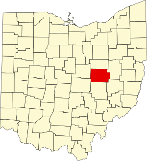
Coshocton County | |
|---|---|
 | |
 Location within the U.S. state of Ohio | |
 Ohio's location within the U.S. | |
| Coordinates: 40°18′N 81°55′W / 40.3°N 81.92°W | |
| Country | |
| State | |
| Founded | April 1, 1811 |
| Named for | "union of waters" or "black bear crossing" in Delaware (Lenape) language |
| Seat | Coshocton |
| Largest city | Coshocton |
| Area | |
• Total | 567 sq mi (1,470 km2) |
| • Land | 564 sq mi (1,460 km2) |
| • Water | 3.6 sq mi (9 km2) 0.6% |
| Population (2020) | |
• Total | 36,612 |
| • Density | 65/sq mi (25/km2) |
| Time zone | UTC−5 (Eastern) |
| • Summer (DST) | UTC−4 (EDT) |
| Congressional district | 12th |
| Website | www |
Coshocton County is a county located in the U.S. state of Ohio. As of the 2020 census, the population was 36,612.[1] Its county seat and largest city is Coshocton.[2] The county lies within the Appalachian region of the state. The county was formed on January 31, 1810, from portions of Muskingum and Tuscarawas Counties and later organized in 1811.[3] Its name comes from the Delaware Indian language and has been translated as "union of waters" or "black bear crossing".[4] Coshocton was mentioned by David Zeisberger in his diary from the 1780s using the German spelling "Goschachgünk".[5] The Coshocton, OH Micropolitan Statistical Area includes all of Coshocton County.
- ^ 2020 census
- ^ "Find a County". National Association of Counties. Archived from the original on May 31, 2011. Retrieved June 7, 2011.
- ^ "Ohio: Individual County Chronologies". Ohio Atlas of Historical County Boundaries. The Newberry Library. 2007. Archived from the original on April 6, 2016. Retrieved February 12, 2015.
- ^ "Coshocton County data". Ohio State University Extension Data Center. Retrieved April 28, 2007.[dead link]
- ^ Diary of David Zeisberger: A Moravian Missionary Among the Indians ..., Volume I, books.google.de

