| Cotopaxi | |
|---|---|
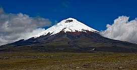
 Cotopaxi seen from the high plain (at least 3,700 m (12,139 ft)) of Cotopaxi National Park | |
| Highest point | |
| Elevation | 5,897 m (19,347 ft) |
| Prominence | 2,500 m (8,202 ft) |
| Listing | Ultra |
| Coordinates | 0°40′50″S 78°26′16″W / 0.68056°S 78.43778°W |
| Geography | |
 | |
| Location | Cotopaxi, Latacunga, Ecuador |
| Parent range | Andes |
| Geology | |
| Mountain type(s) | Stratovolcano, Historical |
| Volcanic arc/belt | South Volcanic Zone |
| Last eruption | 2023 (ongoing) |
| Climbing | |
| First ascent | 28 November 1872 by Wilhelm Reiss and Ángel Escobar |
| Easiest route | North side: Glacier/Snow Climb (Grade PD-) |
Cotopaxi (Spanish pronunciation: [kotoˈpaksi]) is an active stratovolcano in the Andes Mountains, located near Latacunga city of Cotopaxi Province, about 50 km (31 mi) south of Quito, and 31 km (19 mi) northeast of the city of Latacunga, Ecuador.[1] It is the second highest summit in Ecuador (after Chimborazo), reaching a height of 5,897 m (19,347 ft). Cotopaxi is among the highest active volcanoes in the world.
Cotopaxi is known to have erupted 87 times, resulting in the creation of numerous valleys formed by lahars (mudflows) around the volcano.[2] An ongoing eruption began on 21 October 2022.[3]
At the end of February 2023, the Geophysical Institute of Ecuador reported that Cotopaxi had produced around 8,000 earthquakes since October 21, 2022, amounting to 1,600 events per month.[4]
- ^ Cite error: The named reference
globefeedwas invoked but never defined (see the help page). - ^ Cite error: The named reference
gvp_ehwas invoked but never defined (see the help page). - ^ "Global Volcanism Program | Cotopaxi". Smithsonian Institution | Global Volcanism Program. Retrieved 2023-05-09.
- ^ "Ecuador's Cotopaxi volcano produced eight thousand quakes in 4 months - Prensa Latina". 2023-03-01. Retrieved 2024-01-08.
