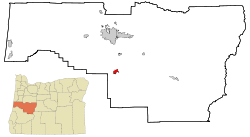
Cottage Grove, Oregon | |
|---|---|
 Cottage Grove Historic District | |
| Nickname: Covered Bridge Capital of Oregon | |
 Location in Oregon | |
| Coordinates: 43°47′46″N 123°03′26″W / 43.79611°N 123.05722°W | |
| Country | United States |
| State | Oregon |
| County | Lane |
| Incorporated | 1887 |
| Government | |
| • Type | Council-manager |
| • City Manager | Michael 'Mike' Sauerwein[1] |
| • Mayor | Candace Solesbee[2] |
| Area | |
| • Total | 3.89 sq mi (10.08 km2) |
| • Land | 3.87 sq mi (10.01 km2) |
| • Water | 0.03 sq mi (0.07 km2) |
| Elevation | 650 ft (200 m) |
| Population | |
| • Total | 10,574 |
| • Density | 2,735.83/sq mi (1,056.32/km2) |
| Time zone | UTC-8 (Pacific) |
| • Summer (DST) | UTC-7 (Pacific) |
| ZIP codes | 97424, 97472 |
| Area code | 541 |
| FIPS code | 41-15950[6] |
| GNIS feature ID | 2410241[4] |
| Website | www.cottagegrove.org |
Cottage Grove is a city in Lane County, Oregon, United States. Its population was 10,643 at the 2020 census.[7] It is the third largest city in Lane County. It is on Interstate 5, Oregon Route 99, and the main Willamette Valley line of the CORP railroad.[8]
- ^ "City Manager Contact Information | Cottage Grove Oregon". www.cottagegroveor.gov. Retrieved April 4, 2024.
- ^ "Mayor & City Council Home | Cottage Grove Oregon". www.cottagegroveor.gov. Retrieved April 4, 2024.
- ^ "ArcGIS REST Services Directory". United States Census Bureau. Retrieved October 12, 2022.
- ^ a b U.S. Geological Survey Geographic Names Information System: Cottage Grove, Oregon
- ^ Cite error: The named reference
USCensusDecennial2020CenPopScriptOnlywas invoked but never defined (see the help page). - ^ "U.S. Census website". United States Census Bureau. Retrieved January 31, 2008.
- ^ "Race, Hispanic or Latino, Age, and Housing Occupancy: 2020 Census Redistricting Data (Public Law 94-171) Summary File (QT-PL), Cottage Grove city, Oregon". United States Census Bureau. Retrieved August 1, 2021.
- ^ Oregon Atlas & Gazetteer (7th ed.). Yarmouth, Maine: DeLorme. 2008. p. 47. ISBN 978-0-89933-347-2.
