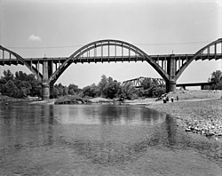
Cotter Bridge | |
|---|---|
 Cotter Bridge, 1988 | |
| Coordinates | 36°16′2″N 92°32′39″W / 36.26722°N 92.54417°W |
| Carries | |
| Crosses | White River |
| Locale | Cotter, Arkansas |
| Official name | R. M. Ruthven Bridge |
| Maintained by | Arkansas State Highway and Transportation Department |
| ID number | AHTD 00702 |
| Characteristics | |
| Design | Marsh Reinforced concrete Arch |
| Total length | 1,850 ft (560 m) |
| Width | 2 lanes, 24 ft (7.3 m) |
| Longest span | 216 ft (66 m)[1] |
| Clearance above | 25 ft (7.6 m) |
| Clearance below | 78 ft (24 m) |
| History | |
| Constructed by | Bateman Contracting Company |
| Construction cost | $390,729.82[1]: 12 |
| Opened | 1930 |
| Location | |
 | |
The Cotter Bridge, also known as the R. M. Ruthven Bridge and the White River Concrete Arch Bridge, carries U.S. Route 62 Business across the White River west of the city of Cotter in Baxter County, Arkansas. Upon completion, the bridge opened a part of the Ozarks previously inaccessible to motorists. Constructed in 1930, it is the only bridge built by the Marsh Engineering Company of Des Moines, Iowa, in the state of Arkansas.
- ^ a b Bennett, Lola; Smith, Corinne (1988). "Cotter Bridge (R. M. Ruthven Bridge)" (PDF). Historic American Engineering Record. Washington, D.C.: Library of Congress. Retrieved November 20, 2021.