| Cotter | |
|---|---|
 Cotter River, 2011 | |
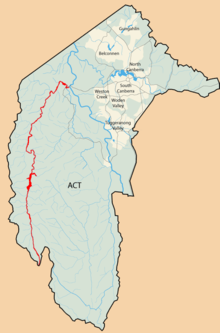
 Map of the Australian Capital Territory, with the Cotter River marked in red | |
| Etymology | In honour of Garrett Cotter[1] |
| Location | |
| Country | Australia |
| Territory | Australian Capital Territory |
| Region | South Eastern Highlands (IBRA), Capital Country |
| Physical characteristics | |
| Source | Scabby Range, Brindabella Ranges |
| • location | below Mount Scabby |
| • coordinates | 35°44′25″S 148°50′21″E / 35.74028°S 148.83917°E |
| • elevation | 1,760 m (5,770 ft)[2] |
| Mouth | confluence with the Murrumbidgee River |
• location | Casuarina Sands |
• coordinates | 35°19′27″S 148°57′1″E / 35.32417°S 148.95028°E |
• elevation | 466 m (1,529 ft)[2] |
| Length | 76 km (47 mi)[2] |
| Basin size | 480.1 km2 (185.4 sq mi)[3] |
| Discharge | |
| • location | immediately downstream Corin Dam |
| • average | 2.21 m3/s (78 cu ft/s) |
| Basin features | |
| River system | Murrumbidgee River, Murray–Darling basin |
| Tributaries | |
| • left | Porcupine Creek, Condor Creek |
| • right | Licking Hole Creek, Long Creek (Australian Capital Territory), Kangaroo Creek, Paddys River (Australian Capital Territory) |
| Reservoirs | Corin, Bendora and Cotter dams |
| [2] | |
The Cotter River, a perennial river of the Murrumbidgee catchment within the Murray–Darling basin, is located in the Australian Capital Territory, Australia. The Cotter River, together with the Queanbeyan River, is one of two rivers that provides potable water to the Canberra and Queanbeyan region.
- ^ "Cotter River". Place name search. Government of the Australian Capital Territory. Retrieved 13 February 2013.
- ^ a b c d "Map of Cotter River". Bonzle Digital Atlas of Australia. Retrieved 13 February 2013.
- ^ Cite error: The named reference
Whitewas invoked but never defined (see the help page).