Cottonwood, Idaho | |
|---|---|
 | |
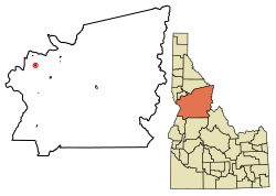
 Location of Cottonwood in Idaho County, Idaho. | |
| Coordinates: 46°3′8″N 116°21′2″W / 46.05222°N 116.35056°W | |
| Country | United States |
| State | Idaho |
| County | Idaho |
| Area | |
• Total | 0.84 sq mi (2.17 km2) |
| • Land | 0.84 sq mi (2.17 km2) |
| • Water | 0.00 sq mi (0.00 km2) |
| Elevation | 3,497 ft (1,066 m) |
| Population | |
• Total | 900 |
• Estimate (2019)[3] | 940 |
| • Density | 1,120.38/sq mi (432.45/km2) |
| Time zone | UTC-8 (Pacific (PST)) |
| • Summer (DST) | UTC-7 (PDT) |
| ZIP codes | 83522 |
| Area code | 208 |
| FIPS code | 16-18640 |
| GNIS feature ID | 0372152 |
Cottonwood is a city in Idaho County, Idaho. On the Camas Prairie in north central Idaho, the population was 822 at the 2020 census,[4] down from 900 in 2010 and 944 in 2000. It is just west of U.S. Route 95, between Grangeville and Lewiston.
- ^ "2019 U.S. Gazetteer Files". United States Census Bureau. Retrieved July 9, 2020.
- ^ Cite error: The named reference
wwwcensusgovwas invoked but never defined (see the help page). - ^ Cite error: The named reference
USCensusEst2019CenPopScriptOnlyDirtyFixDoNotUsewas invoked but never defined (see the help page). - ^ "Explore Census Data". data.census.gov. Retrieved April 30, 2024.