| Cottonwood Limestone | |
|---|---|
| Stratigraphic range: (Gearyan stage)[1] | |
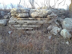
 Well-exposed natural outcrop of the Cottonwood Limestone alongside the Konza Prairie Nature Trail | |
| Type | Formation Member |
| Unit of | Beattie Limestone |
| Sub-units | Top Ledge, Bottom Ledge |
| Underlies | Florena Shale member of the Beattie Limestone formation |
| Overlies | Eskridge Shale |
| Thickness | 3–7 ft (0.91–2.13 m) often ~6 ft (1.8 m) |
| Lithology | |
| Primary | Limestone |
| Other | Calcareous shale and siliceous to quartz[clarification needed] nodules or infills of burrows |
| Location | |
| Region | Mid-continental |
| Country | |
| Extent | Outcrops from southeast Nebraska to northeast-central Oklahoma[2] |
| Type section | |
| Named for | Cottonwood Falls, Kansas |
| Named by | Prosser, C. S. |
| Year defined | 1894-5[3][4] |
Cottonwood Limestone, or simply the Cottonwood,[5] is a stratigraphic unit and a historic stone resource in east-central Kansas, northeast-central Oklahoma, and southeastern Nebraska in the Midwestern United States.[2] It is the lowest member of the Beattie Limestone formation and commonly outcrops within the deep valleys and on top of the scenic residual ridges of the Flint Hills.
This important building stone, quarried in the Cottonwood River valley, had been used under the names "Cottonwood stone" or "Cottonwood Falls limestone" many years before the name Cottonwood Limestone appeared in scientific publications late in the 19th century. Similarly, "Manhattan stone" was the commercial name used for the same limestone when quarried in the vicinity of Manhattan, Kansas.[4] It was also called "Alma Limestone" when first quarried at Alma, Kansas.[6][7]
The Cottonwood Limestone is one of the most persistent and easily recognizable horizons in Kansas.[6][8] This limestone is usually light gray or buff in color, massively bedded, and has an average thickness of about six feet. The upper part of the member in particular is recognizable for being almost entirely made up of the small wheat-grain shaped foraminifera Fusulinida, with few other animal remains. The line of outcrop of the Cottonwood is generally marked by a line of massive rectangular blocks of light gray or bleached, bone-colored limestone, often supporting a line of shrubs. Because of its resistance to weathering, it often forms a prominent escarpment. The Cottonwood Limestone is noteworthy for the persistence of this lithologic character across its range.
- ^ D. E. Zeller, ed. (1968). "The Stratigraphic Succession in Kansas". Kansas Geological Survey Bulletin (189). University of Kansas Publications, State Geological Survey of Kansas: Permian System. Retrieved 2024-06-08.
The Gearyan Stage (O'Connor, 1963) comprises three groups, the Admire, the Council Grove, and the Chase. It contains about 790 feet of rocks, which are predominantly limestone and shale, and contains units that are remarkably continuous laterally. The Gearyan Stage is named from Geary County in northeastern Kansas. Rocks of this stage are exposed throughout east-central Kansas in a north-northeast-trending belt from Cowley County on the Oklahoma border to Marshall and Brown counties on the Nebraska border.
- ^ a b Cite error: The named reference
Imbrie64was invoked but never defined (see the help page). - ^ C.A. Prosser (1894). "Kansas River Section of the Permo-Carboniferous and Permian Rocks of Kansas" (PDF). Bulletin of the Geological Society of America. 6: 29-54. Note: A significant theme of this work is the overview, comparison, and correlation of the prior publication on the Permian rocks of Kansas.
- ^ a b Jewett, John M. (1941). The Geology of Riley and Geary Counties, Kansas, Kansas Geological Survey Bulletin 39. University of Kansas Publications, State Geological Survey of Kansas.
- ^ Susan Ward Aber; David A. Grisafe (1982). Petrographic Characteristics of Kansas Building Limestones, Kansas Geological Survey, Bulletin 224. University of Kansas Publications, State Geological Survey of Kansas.
- ^ a b Cite error: The named reference
prosser04was invoked but never defined (see the help page). - ^ "Geologic Unit: Alma". Geolex – National Geologic Database. United States Geological Survey. Retrieved 2015-02-21.
- ^ Raymond C. Moore (1920). Oil and Gas Resources of Kansas, Kansas Geological Survey Bulletin 6, Part II. p. 55.