Cotuit, Massachusetts | |
|---|---|
Village | |
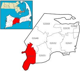
 Location of ZIP code 02635 Cotuit within the Town of Barnstable, county, and state | |
| Coordinates: 41°37′00″N 70°26′13″W / 41.61667°N 70.43694°W | |
| Country | United States |
| State | Massachusetts |
| County | Barnstable |
| Town | Barnstable, MA |
| Area | |
| • Total | 6.60 sq mi (17.10 km2) |
| • Land | 5.50 sq mi (14.25 km2) |
| • Water | 1.10 sq mi (2.85 km2) |
| Population (1995 estimate) | |
| • Total | 3,296 |
| • Density | 599.3/sq mi (231.38/km2) |
| Time zone | UTC-5 (Eastern (EST)) |
| • Summer (DST) | UTC-4 (EDT) |

Cotuit (/kəˈtuɪt/ kə-TOO-it) is one of the villages of the Town of Barnstable on Cape Cod in Barnstable County, Massachusetts, United States. Located on a peninsula on the south side of Barnstable about midway between Falmouth and Hyannis, Cotuit is bounded by the Santuit River to the west on the Mashpee town line, the villages of Marstons Mills to the north and Osterville to the east, and Nantucket Sound to the south. Cotuit is primarily residential with several small beaches including Ropes Beach, Riley's Beach, The Loop Beach and Oregon Beach.