County Londonderry
| |
|---|---|
| Nickname: The Oak Leaf County | |
| Motto(s): | |
 | |
| Country | United Kingdom |
| Region | Northern Ireland |
| Province | Ulster |
| Established | Date |
| County Coleraine | 1585 |
| County Londonderry | 1613 |
| County town | Coleraine |
| Area | |
| • Total | 818 sq mi (2,118 km2) |
| • Rank | 15th |
| Highest elevation | 2,224 ft (678 m) |
| Population (2021) | 252,231 |
| • Rank | 6th[2] |
| Time zone | UTC±0 (GMT) |
| • Summer (DST) | UTC+1 (BST) |
| Postcode area | |
| Contae Dhoire[3] is the Irish name; Coontie Lunnonderrie is its name in Ulster Scots.[4] | |
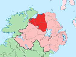
County Londonderry (Ulster-Scots: Coontie Lunnonderrie), also known as County Derry (Irish: Contae Dhoire), is one of the six counties of Northern Ireland, one of the thirty-two counties of Ireland and one of the nine counties of Ulster. Before the partition of Ireland, it was one of the counties of the Kingdom of Ireland from 1613 onward and then of the United Kingdom after the Acts of Union 1800. Adjoining the north-west shore of Lough Neagh, the county covers an area of 2,118 km2 (818 sq mi) and today has a population of about 252,231.[2]
Since 1972, the counties in Northern Ireland, including Londonderry, have no longer been used by the state as part of the local administration. Following further reforms in 2015, the area is now governed under three different districts: Derry and Strabane, Causeway Coast and Glens and Mid-Ulster. Despite no longer being used for local government and administrative purposes, it is sometimes used in a cultural context in All-Ireland sporting and cultural events (i.e. Derry GAA).
Since 1981, it has become one of four counties in Northern Ireland that has a Catholic majority (55.56% according to the 2001 Census[5] and 61.3% according to the 2021 Census[6]). The county flower is the purple saxifrage.[7]
- ^ Northern Ireland General Register Office (1975). "Table 1: Area, Buildings for Habitation and Population, 1971". Census of Population 1971; Summary Tables (PDF). Belfast: HMSO. p. 1. Archived (PDF) from the original on 23 July 2019. Retrieved 28 August 2019.
- ^ a b "County". NISRA. Retrieved 18 August 2023.
- ^ "Northern Ireland" (PDF). Ministry of Defence (United Kingdom). Archived from the original on 7 January 2019. Retrieved 28 October 2010.
- ^ Banagher and Boveagh Churches Archived 30 August 2011 at the Wayback Machine Department of the Environment.
- ^ "NISRA – Northern Ireland Statistics and Research Agency (c) 2015" (PDF). Archived from the original (PDF) on 27 November 2007.
- ^ "Religion or religion brought up in". NISRA. Retrieved 17 August 2023.
- ^ County flowers in Britain Archived 14 February 2006 at the Wayback Machine www.plantlife.org.uk
