| Carnarvon South Australia | |||||||||||||||
|---|---|---|---|---|---|---|---|---|---|---|---|---|---|---|---|
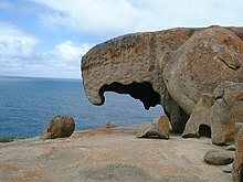
 Remarkable Rocks formation in Flinders Chase within the Hundred of McDonald | |||||||||||||||
| Coordinates | 35°48′29″S 137°17′04″E / 35.807920°S 137.284350°E | ||||||||||||||
| Established | 1874[1] | ||||||||||||||
| LGA(s) | Kangaroo Island Council | ||||||||||||||
| Region | Fleurieu and Kangaroo Island[2] | ||||||||||||||
| |||||||||||||||
| Footnotes | Coordinates[1] | ||||||||||||||
County of Carnarvon is a cadastral unit located in the Australian state of South Australia which covers the full extent of Kangaroo Island. It was proclaimed in 1874 by Governor Musgrave in response to the demand for agriculture land on Kangaroo Island.
- ^ a b "Search result for "County of Carnarvon (CNTY)" (Record no SA0012503) with the following layers selected - "Counties" and "Hundreds"". Property Location Browser. Land Services, Department of Planning, Transport and Infrastructure, Government of South Australia. Archived from the original on 7 December 2015. Retrieved 7 May 2016.
- ^ "Fleurieu and Kangaroo Island SA Government region" (PDF). The Government of South Australia. Retrieved 10 October 2014.
