| Hamley South Australia | |||||||||||||||
|---|---|---|---|---|---|---|---|---|---|---|---|---|---|---|---|
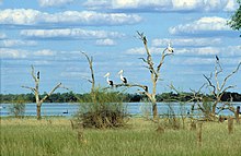
 Pelicans, black swans, cormorants and other water birds at Coombool Swamp, Chowilla | |||||||||||||||
| Coordinates | 33°47′20″S 140°41′49″E / 33.789°S 140.697°E | ||||||||||||||
| Established | 1869[1] | ||||||||||||||
| Area | 5,790 square kilometres (2,236 sq mi)[2] | ||||||||||||||
| LGA(s) | Berri Barmera Council Renmark Paringa Council Unincorporated area[2] | ||||||||||||||
| Region | Murray and Mallee[2][3] | ||||||||||||||
| |||||||||||||||
| Footnotes | Coordinates[2] Adjoining counties[4] | ||||||||||||||
The County of Hamley is a cadastral unit (i.e., a comprehensively surveyed and mapped division of land) located in the Australian state of South Australia covers land located in the state's east north of the Murray River, bordering New South Wales and Victoria. It was proclaimed in 1869 by Governor Fergusson and named after Francis Hamley.
- ^ "New Counties" (PDF). The South Australian Government Gazette. 1869. Government of South Australia: 248. 18 February 1869. Retrieved 9 August 2016.
- ^ a b c d "Search result for "County of Hamley (CNTY)" (Record no SA0029141) with the following layers selected - "Local Government Areas", "Counties", "Hundreds" and "Government Regions"". Property Location Browser. Government of South Australia. Archived from the original on 12 October 2016. Retrieved 9 August 2016.
- ^ "Murray and Mallee SA Government region" (PDF). Government of South Australia. Retrieved 9 August 2016.
- ^ Cite error: The named reference
hundreds-mapwas invoked but never defined (see the help page).
