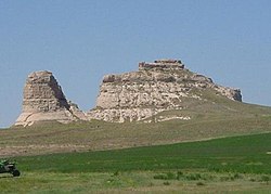
Courthouse and Jail House Rocks | |
 Courthouse and Jail Rocks | |
| Nearest city | Bridgeport, Nebraska |
|---|---|
| Coordinates | 41°35′49″N 103°06′57″W / 41.59694°N 103.11583°W |
| Area | 917 acres (371 ha) |
| NRHP reference No. | 73001067[1] |
| Added to NRHP | April 24, 1973 |

Courthouse and Jail Rocks are two rock formations located near Bridgeport in the Nebraska Panhandle.
The Oregon-California Trail, the Mormon Trail, the Pony Express Trail and the Sidney-Deadwood Trail all ran near the rocks. The pair of rock formations served as a landmark along the trails for many pioneers traveling west in the 19th century. Many travelers would stray as much as five miles (8.0 km) from the Oregon Trail just to get a glimpse of the rocks.
Hundreds of westward-bound emigrants mentioned Courthouse Rock (originally also McFarlan's Castle) in their travel logs and journals. The name "Courthouse" was first used in 1837.[3] In 1845, one traveler described the rock as "resembling the ruins of an old castle [which] rises abruptly from the plain....It is difficult to look upon it and not believe that art had something to do with its construction. The voyagers have called it the Courthouse; but it looks infinitely more like the Capitol."[4]
Courthouse and Jail Rocks, which rise 400 feet (120 m) above the North Platte Valley, are composed of Brule clay, Gering sandstone and volcanic ash. The rock formations are listed in the National Register of Historic Places and in the Nebraska Natural Areas Register.
- ^ "National Register Information System". National Register of Historic Places. National Park Service. July 9, 2010.
- ^ Darton, N.H. 1903. Preliminary report on the geology and water resources of Nebraska west of the one hundred and third meridian. United States Department of the Interior, U.S. Geological Survey, Professional Paper 17, 69 pp. (See Plate V)
- ^ Mattes, M.J. 1987. The Great Platte River Road. Lincoln: University of Nebraska Press, p. 348
- ^ Mattes, M.J. 1987. The Great Platte River Road. Lincoln: University of Nebraska Press, p. 349-350

