Coweta, Oklahoma | |
|---|---|
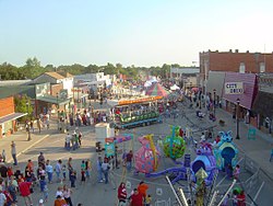
 Coweta Fall Festival, September 2007, courtesy of Caleb Long | |
 Location of Coweta, Oklahoma | |
| Coordinates: 35°57′47″N 95°39′42″W / 35.96306°N 95.66167°W | |
| Country | United States |
| State | Oklahoma |
| County | Wagoner |
| Area | |
• Total | 10.71 sq mi (27.73 km2) |
| • Land | 10.58 sq mi (27.41 km2) |
| • Water | 0.12 sq mi (0.32 km2) |
| Elevation | 663 ft (202 m) |
| Population (2020) | |
• Total | 9,654 |
| • Density | 912.13/sq mi (352.16/km2) |
| Time zone | UTC-6 (Central (CST)) |
| • Summer (DST) | UTC-5 (CDT) |
| ZIP code | 74429 |
| Area code(s) | 539/918 |
| FIPS code | 40-17800[2] |
| GNIS feature ID | 1091781[3] |
| Website | City of Coweta |
Coweta is a city in Wagoner County, Oklahoma, United States, a suburb of Tulsa. As of 2010, its population was 9,943.[4] Part of the Creek Nation in Indian Territory before Oklahoma became a U.S. state, the town was first settled in 1840.[5]
- ^ "ArcGIS REST Services Directory". United States Census Bureau. Retrieved September 20, 2022.
- ^ "U.S. Census website". United States Census Bureau. Retrieved January 31, 2008.
- ^ "US Board on Geographic Names". United States Geological Survey. October 25, 2007. Retrieved January 31, 2008.
- ^ "Profile of General Population and Housing Characteristics: 2010". U.S. Census Bureau. Archived from the original on May 21, 2019. Retrieved July 17, 2011.
- ^ [1] Walters, Norma. Encyclopedia of Oklahoma History and Culture. "Coweta."