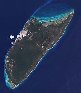
 Satellite image of Cozumel Island in 2001 | |
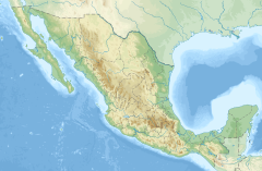
 Location of Cozumel in Quintana Roo State | |
| Geography | |
|---|---|
| Location | Caribbean Sea |
| Coordinates | 20°25′N 86°55′W / 20.42°N 86.92°W |
| Total islands | 2 |
| Area | 647.33 km2 (249.94 sq mi) |
| Highest point | 14 m |
| Administration | |
Mexico | |
| State | Quintana Roo |
| Municipality | Cozumel |
| Largest settlement | San Miguel de Cozumel (pop. 84 915) |
| Presidente municipal (Municipal president) | Juanita Obdulia Alonso Marrufo (Morena) |
| Demographics | |
| Population | 88 626 (2020) |
| Pop. density | 154.5/km2 (400.2/sq mi) |
| Ethnic groups | Mestizo, Maya, White Mexicans, Afro-Mexicans |
| Additional information | |
| Time zone | |
| Official website | cozumel.gob.mx |
| Official name | Parque Nacional Arrecifes de Cozumel |
| Designated | February 2, 2005 |
| Reference no. | 1449[1] |
| Official name | Manglares y Humedales del Norte de Isla Cozumel |
| Designated | February 2, 2009 |
| Reference no. | 1921[2] |
Cozumel (Spanish pronunciation: [kosuˈmel]; Yucatec Maya: Kùutsmil) is an island and municipality in the Caribbean Sea off the eastern coast of Mexico's Yucatán Peninsula, opposite Playa del Carmen. It is separated from the mainland by the Cozumel Channel and is close to the Yucatán Channel. The municipality is part of the state of Quintana Roo, Mexico.
- ^ "Parque Nacional Arrecifes de Cozumel". Ramsar Sites Information Service. Archived from the original on June 13, 2018. Retrieved April 25, 2018.
- ^ "Manglares y Humedales del Norte de Isla Cozumel". Ramsar Sites Information Service. Archived from the original on July 18, 2018. Retrieved April 25, 2018.
