| Crace Canberra, Australian Capital Territory | |||||||||||||||
|---|---|---|---|---|---|---|---|---|---|---|---|---|---|---|---|
 | |||||||||||||||
| Coordinates | 35°12′08″S 149°06′23″E / 35.20222°S 149.10639°E | ||||||||||||||
| Population | 4,800 (SAL 2021)[1] | ||||||||||||||
| Established | 2010 | ||||||||||||||
| Postcode(s) | 2911 | ||||||||||||||
| Elevation | 611 m (2,005 ft) | ||||||||||||||
| Area | 1.7 km2 (0.7 sq mi) | ||||||||||||||
| Location |
| ||||||||||||||
| District | Gungahlin | ||||||||||||||
| Territory electorate(s) | Yerrabi | ||||||||||||||
| Federal division(s) | Fenner | ||||||||||||||
| |||||||||||||||
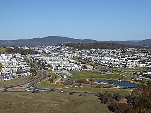
Crace (/kreɪs/) is a suburb of Canberra, Australia in the district of Gungahlin. It was named after Edward Kendall Crace an original settler in the Gungahlin area. Streets in Crace are named after parishes and land divisions from colonial times.[2] It is bounded by the Barton Highway, Gundaroo Drive, Nudurr Drive and Gungahlin Drive. Located in the suburb is the Canberra Nature Park of Gungaderra Grasslands nature reserve.[3] At the 2016 census, it had a population of 4,459.[4]
- ^ Australian Bureau of Statistics (28 June 2022). "Crace (suburb and locality)". Australian Census 2021 QuickStats. Retrieved 28 June 2022.
- ^ "Suburb Name search results". ACT Planning & Land Authority. Retrieved 7 February 2009. [dead link]
- ^ "Canberra Nature Park" (PDF). Archived from the original (PDF) on 26 March 2012. Retrieved 27 August 2014. CRACE GRASSLANDS NATURE RESERVE
- ^ Australian Bureau of Statistics (27 June 2017). "Crace (State Suburb)". 2016 Census QuickStats. Retrieved 28 June 2017.
