Cradock | |
|---|---|
| Nxuba | |
 Cradock | |
| Coordinates: 32°09′54″S 25°37′03″E / 32.16500°S 25.61750°E | |
| Country | South Africa |
| Province | Eastern Cape |
| District | Chris Hani |
| Municipality | Inxuba Yethemba |
| Established | 1816[1] |
| Area | |
• Total | 118.57 km2 (45.78 sq mi) |
| Population (2011)[2] | |
• Total | 8,626 |
| • Density | 73/km2 (190/sq mi) |
| Racial makeup (2011) | |
| • White | 50.0% |
| • Black African | 30.5% |
| • Coloured | 17.9% |
| • Indian/Asian | 0.9% |
| • Other | 0.7% |
| First languages (2011) | |
| • Afrikaans | 68.8% |
| • Xhosa | 20.0% |
| • English | 7.9% |
| • Other | 2.3% |
| Time zone | UTC+2 (SAST) |
| Postal code (street) | 5880 |
| PO box | 5880 |
| Area code | 048 |
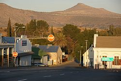
Cradock, officially Nxuba,[3] is a town in the Eastern Cape Province of South Africa, in the upper valley of the Great Fish River, 250 kilometres (160 mi) by road northeast of Port Elizabeth. The town is the administrative seat of the Inxuba Yethemba Local Municipality in the Chris Hani District of the Eastern Cape.
The town is named after John Cradock, governor of the Cape Colony in early 19th century and commander of the forces.[4]
- ^ Cite error: The named reference
establishedwas invoked but never defined (see the help page). - ^ a b c d "Sub Place Cradock". Census 2011. Archived from the original on 11 July 2021. Retrieved 30 June 2021.
- ^ "85 towns hit with name changes in South Africa – and more are on the way". BusinessTech. 14 April 2024. Retrieved 26 September 2024.
- ^ Cite error: The named reference
Raper1989was invoked but never defined (see the help page).


