| Craig y Llyn | |
|---|---|
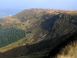
 The west face of Craig y Llyn | |
| Highest point | |
| Elevation | 600 m (2,000 ft) |
| Prominence | 392 m (1,286 ft) |
| Listing | Marilyn, council top |
| Coordinates | 51°42′57″N 3°35′06″W / 51.71592°N 3.58497°W |
| Naming | |
| English translation | cliff of the lake |
| Language of name | Welsh |
| Pronunciation | Welsh: [krai̯ɡ ə ɬɪn] |
| Geography | |
| OS grid | SN906031 |
| Topo map | OS Landranger 170 |
Craig y Llyn (Welsh, 'rock/cliff of the lake') is a mountain situated to the south of the village of Rhigos in the Cynon Valley on the south side of the upper Vale of Neath and north of the Rhondda Valleys in South Wales; it is the highest point in the ancient kingdom and, later, county of Glamorgan (Morgannwg), and the southern Welsh coalfield plateau.
