| Crescent Lake | |
|---|---|
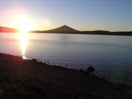
 Crescent Lake at sunrise with Odell Butte in the background | |
| Location | Klamath County, Oregon |
| Coordinates | 43°28′32.2″N 121°59′31.2″W / 43.475611°N 121.992000°W |
| Type | Natural lake (with dam) |
| Primary inflows | Summit Creek |
| Primary outflows | Crescent Creek |
| Catchment area | 57 sq mi (150 km2) |
| Basin countries | United States |
| Max. length | 5 mi (8.0 km) |
| Max. width | 4 mi (6.4 km) |
| Surface area | 4,547 acres (18.40 km2) |
| Average depth | 124 ft (38 m) |
| Max. depth | 265 ft (81 m) |
| Water volume | 566,600 acre-feet (698,900,000 m3) |
| Residence time | 13 years |
| Shore length1 | 12.4 mi (20.0 km) |
| Surface elevation | 4,839 ft (1,475 m) |
| References | [1][2] |
| 1 Shore length is not a well-defined measure. | |
Crescent Lake is a natural lake on the eastern side of the Cascade Range in the northwest corner of Klamath County, Oregon, United States. The unincorporated community of Crescent Lake Junction on Oregon Route 58 and Crescent Lake State Airport are located 2.5 miles (4.0 km) northeast of the lake. The lake was named for its shape by Byron J. Pengra and William Holman Odell in July 1865.[3]
- ^ Johnson, Daniel M., ed. (1985). Atlas of Oregon Lakes. Petersen, Richard R. - Lycan, D. Richard - Sweet, James W. - Neuhaus, Mark E. - Schaedel, Andrew L. Corvallis: Oregon State University Press. ISBN 0-87071-343-4.
- ^ "Crescent Lake, Deschutes & Ochoco National Forests". USFS. Retrieved 2021-03-01.
- ^ McArthur, Lewis A (1926). "Oregon Geographic Names". The Quarterly of the Oregon Historical Society. 27 (2): 225–264. JSTOR 20610348. Retrieved 2021-02-27.

