| Crewe | |
|---|---|
| Town | |
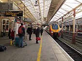
Clockwise, from top: Crewe Municipal Buildings, Crewe railway station, Market Hall, Crewe Arms Hotel and Crewe Town Clock | |
Location within Cheshire | |
| Population | 76,437 (built-up area, 2021)[1] |
| OS grid reference | SJ705557 |
| • London | 147 miles (237 km)[2] SE |
| Civil parish |
|
| Unitary authority | |
| Ceremonial county | |
| Region | |
| Country | England |
| Sovereign state | United Kingdom |
| Post town | CREWE |
| Postcode district | CW1, CW2 |
| Dialling code | 01270 |
| Police | Cheshire |
| Fire | Cheshire |
| Ambulance | North West |
| UK Parliament | |
| Website | Crewe Town Council |
Crewe (/kruː/ ) is a railway town and civil parish in the unitary authority of Cheshire East in Cheshire, England. The civil parish of Crewe had a population of 55,318 in the 2021 census.[3] The larger Crewe built-up area, which also covers parts of the adjacent civil parishes of Willaston, Shavington cum Gresty and Wistaston, had a total population of 76,437 in 2021.[1]
Crewe is perhaps best known as a large railway junction and home to Crewe Works; for many years, it was a major railway engineering facility for manufacturing and overhauling locomotives, but now much reduced in size. From 1946 until 2002, it was also the home of Rolls-Royce motor car production. The Pyms Lane factory on the west of the town now exclusively produces Bentley motor cars. Crewe is 158 miles (254 km) northwest of London, 28 miles (45 km) south of Manchester city centre, and 31 miles (50 km) southeast of Liverpool city centre.
- ^ a b "CREWE in Cheshire East (North West England) Built-up Area Subdivision". City Population. Retrieved 5 February 2023.
- ^ "Coordinate Distance Calculator". boulter.com. Archived from the original on 8 March 2016. Retrieved 8 March 2016.
- ^ "CREWE Parish in North West England". City Population. Retrieved 5 February 2023.


