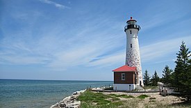
 Crisp Point Light in June 2021 | |
 | |
| Location | Lake Superior shoreline McMillan Township, Michigan |
|---|---|
| Coordinates | 46°45.173′N 85°15.440′W / 46.752883°N 85.257333°W |
| Tower | |
| Foundation | poured concrete |
| Construction | brick |
| Height | 58 feet (18 m) |
| Shape | conical |
| Markings | White W/Black Lantern |
| Light | |
| First lit | 1904 |
| Deactivated | 1992-2013 |
| Focal height | 62 feet (19 m) |
| Lens | Fourth Order Fresnel lens |
| Range | 13 nautical miles; 24 kilometres (15 mi)[citation needed] |
| Characteristic | Fl W 6s |
Crisp Point was one of five U.S. Life-Saving Service Stations along the coast of Lake Superior between Munising and Whitefish Point in the Upper Peninsula of Michigan. The lighthouse is within McMillan Township in Luce County.
Located about 14 miles (23 km) west of Whitefish Point, in 1876 it became Life Saving Station Number Ten, of the U.S. Life-Saving Service District 10 (later part of District 11). Crisp Point is named from one of the Life Saving Station keepers, Christopher Crisp, who is said to have been "an iron-willed boatman." Surfmen were stationed there to aid mariners and ships in distress. The station, along with the rest of the United States Life-Saving Service, was integrated into the United States Coast Guard in 1915. (In 1939 the U.S. Lighthouse Service also merged under the control of the Coast Guard). Due to the fact that the US Life-Saving Service and the US Lighthouse Service were originally two distinct entities, the Crisp Point Life Saving Station and the Crisp Point Lighthouse were also originally two separate entities.
The other four Life-Saving Stations were Vermilion Point (now Vermilion, Michigan), about five miles (8 km) east of Crisp Point, Two Hearted River, 5 or 6 miles (8.0 or 9.7 km) west of Crisp Point, Deer Park, Michigan (formerly known as the Sucker River Station and Muskallonge Lake Station), about 10 or 11 miles (16 or 18 km) west of Two Hearted River, and Grand Marais about 15 or 16 miles (24 or 26 km) west of Deer Park.[1]