Croftfoot
| |
|---|---|
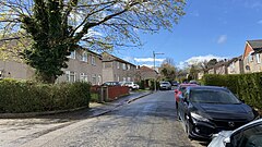
 Midcroft Avenue in Croftfoot | |
Location within Glasgow | |
| Population | 5,800 |
| OS grid reference | NS601601 |
| Council area | |
| Lieutenancy area |
|
| Country | Scotland |
| Sovereign state | United Kingdom |
| Post town | GLASGOW |
| Postcode district | G44 5 |
| Dialling code | 0141 |
| Police | Scotland |
| Fire | Scottish |
| Ambulance | Scottish |
| UK Parliament | |
| Scottish Parliament | |
Croftfoot (Scots: Croaftfuit, Scottish Gaelic: Bun a' Chroit)[1] is a residential area on the southeastern side of the Scottish city of Glasgow. It is bordered by Castlemilk to the south and King's Park (both the public park and the residential neighbourhood)[2] to the west within Glasgow, and by the Rutherglen areas of Spittal to the east and Bankhead to the north (across the Cathcart Circle Lines railway). Historically within the civil parish of Cathcart in Renfrewshire,[3] it is within the Linn ward of Glasgow City Council.
