| Cronulla Sydney, New South Wales | |||||||||||||||
|---|---|---|---|---|---|---|---|---|---|---|---|---|---|---|---|
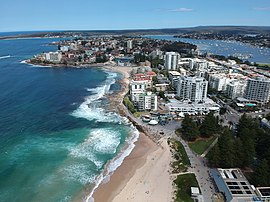
 Cronulla, New South Wales, pictured facing south in September 2019. | |||||||||||||||
 | |||||||||||||||
| Population | 17,899 (2021 census)[1] | ||||||||||||||
| Established | 1908 | ||||||||||||||
| Postcode(s) | 2230 | ||||||||||||||
| Elevation | 20 m (66 ft) | ||||||||||||||
| Location | 26 km (16 mi) south of Sydney CBD | ||||||||||||||
| LGA(s) | Sutherland Shire | ||||||||||||||
| State electorate(s) | Cronulla | ||||||||||||||
| Federal division(s) | Cook | ||||||||||||||
| |||||||||||||||

Cronulla is a suburb of Sydney, in the state of New South Wales, Australia. Boasting numerous surf beaches and swimming spots, the suburb attracts both tourists and Greater Sydney residents. Cronulla is 26 kilometres south of the Sydney central business district, in the local government area of the Sutherland Shire.
Cronulla is on a peninsula framed by Botany Bay to the north, Bate Bay to the east, Port Hacking to the south, and Gunnamatta Bay to the west. The neighbouring suburb of Woolooware lies to the west of Cronulla, and Burraneer lies to the southwest. The Kurnell peninsula, the site of the first landfall on the eastern coastline made by Captain James Cook in 1770, is reached by driving northeast out of Cronulla on Captain Cook Drive.
- ^ Australian Bureau of Statistics (28 June 2022). "Cronulla (State Suburb)". 2021 Census QuickStats. Retrieved 27 November 2023.