Croom | |
|---|---|
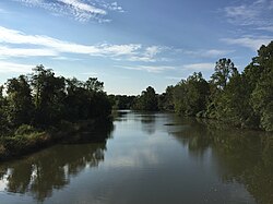
 The Patuxent River forms the eastern boundary of Croom | |
| Coordinates: 38°45′9″N 76°45′50″W / 38.75250°N 76.76389°W | |
| Country | |
| State | |
| County | |
| Area | |
• Total | 35.41 sq mi (91.70 km2) |
| • Land | 34.19 sq mi (88.56 km2) |
| • Water | 1.21 sq mi (3.14 km2) |
| Population (2020) | |
• Total | 2,720 |
| • Density | 79.55/sq mi (30.71/km2) |
| Time zone | UTC−5 (Eastern (EST)) |
| • Summer (DST) | UTC−4 (EDT) |
| FIPS code | 24-20925 |
| GNIS feature ID | 597296 |
Croom is an unincorporated community and census-designated place in Southern Prince George's County, Maryland, United States.[2] As of the 2020 census it had a population of 2,720.[3] Croom largely consists of former tobacco farms and forests converted to Washington bedroom subdivisions such as nearby Marlton. The main (Jug Bay Natural Area) part of Patuxent River Park is in Croom.
- ^ "2020 U.S. Gazetteer Files". United States Census Bureau. Retrieved April 26, 2022.
- ^ U.S. Geological Survey Geographic Names Information System: Croom, Maryland
- ^ "Croom CDP, Maryland". United States Census Bureau. Retrieved March 13, 2022.

