Parts of this article (those related to demographics) need to be updated. (November 2015) |
Cross County | |
|---|---|
|
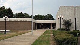
Clockwise from top: Cross County Courthouse, the railroad overpass in Wynne, Lake Austell at Village Creek State Park, a sorghum field with Wynne grain elevator in the background, a preserved Native American mound at Parkin Archaeological State Park, and streetside in the Wynne Commercial Historic District | |
 Location within the U.S. state of Arkansas | |
 Arkansas's location within the U.S. | |
| Coordinates: 35°17′30″N 90°46′24″W / 35.291666666667°N 90.773333333333°W | |
| Country | |
| State | |
| Founded | November 15, 1862 |
| Named for | David C. Cross |
| Seat | Wynne |
| Largest city | Wynne |
| Area | |
• Total | 622.33 sq mi (1,611.8 km2) |
| • Land | 615.85 sq mi (1,595.0 km2) |
| • Water | 6.48 sq mi (16.8 km2) 1.0% |
| Population (2020) | |
• Total | 16,833 |
| • Density | 27/sq mi (10/km2) |
| Time zone | UTC−6 (Central) |
| • Summer (DST) | UTC−5 (CDT) |
| Congressional district | 1st |
| Website | crosscountyar |
Cross County is a rural Northeast Arkansas county in the Arkansas Delta. Created as Arkansas's 53rd county on November 15, 1862, Cross County contains four incorporated municipalities, including Wynne, the county seat and most populous city. It is named for Confederate Colonel David C. Cross, a political leader in the area.
The county is largely flat and fertile, mostly used for row agriculture typical of the rich alluvial soils of the Arkansas Delta. Crowley's Ridge, a forested deposit of loess hills rising from the flat Delta bisects the county from north to south, including part of Wynne and most of Village Creek State Park, the county's primary protected area of ecological value. Historical and cultural features range from Parkin Archeological State Park, which preserves a prehistoric Native American mound building settlement, to the Johnston Cotton Gin marking mechanization of the cotton farm, and the Northern Ohio School, a segregated school built by a lumber company for African-American children of employees.
Cross County occupies 622.33 square miles (1,612 ha) and contained a population of 16,833 as of the 2020 census.[2] The economy is largely based on agriculture. Poverty and unemployment rates are above national averages, household incomes are below state and national averages.
Cross County is mostly served by two school districts: Cross County School District and Wynne Public Schools. Higher education is provided at the Wynne campus of East Arkansas Community College, a public community college. Crossridge Community Hospital in Wynne is a community hospital providing primary care in the county. Although no Interstate highways serve Cross County, the county has access to two United States highways (US Highway 49 [US 49] and US 64) and thirteen Arkansas state highways. Cross County is also served by one public owned/public use general aviation airport, Wynne Municipal Airport, and seven community water systems provide potable water to customers in the county.
- ^ Arkansas State Highway and Transportation Department in cooperation with the U.S. Department of Transportation (October 16, 2014). Arkansas County Polygons (SHP file) (Map). Arkansas GIS Office. Retrieved January 1, 2017.
- ^ "Census - Geography Profile: Cross County, Arkansas". United States Census Bureau. Retrieved January 19, 2023.


