| Croydon Park Sydney, New South Wales | |||||||||||||||
|---|---|---|---|---|---|---|---|---|---|---|---|---|---|---|---|
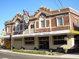
 Croydon Park Hotel | |||||||||||||||
 | |||||||||||||||
| Population | 10,929 (2021 census)[1] | ||||||||||||||
| • Density | 4,286/km2 (11,100/sq mi) | ||||||||||||||
| Established | 1914 | ||||||||||||||
| Postcode(s) | 2133 | ||||||||||||||
| Elevation | 11 m (36 ft) | ||||||||||||||
| Area | 2.55 km2 (1.0 sq mi) | ||||||||||||||
| Location | 10 km (6 mi) SW of Sydney CBD | ||||||||||||||
| LGA(s) | |||||||||||||||
| State electorate(s) | Strathfield | ||||||||||||||
| Federal division(s) | Watson | ||||||||||||||
| |||||||||||||||


Croydon Park is a suburb in the Inner West of Sydney, in the state of New South Wales, Australia. Croydon Park is 10 kilometres south-west of the Sydney central business district and is divided between the local government areas of the City of Canterbury-Bankstown, Municipality of Burwood and Inner West Council. Croydon is a separate suburb, to the north.
Croydon Park has a commercial shopping strip along Georges River Road and is in proximity to larger shopping and town centres of Burwood, Ashfield and Campsie. Croydon Park is relatively large compared to neighbouring suburbs. It is largely residential, but has a commercial strip along Georges River Road, a local arterial that runs through the centre of the suburb.
- ^ Australian Bureau of Statistics (28 June 2022). "Croydon Park (NSW)". 2021 Census QuickStats. Retrieved 13 November 2024.