You can help expand this article with text translated from the corresponding article in Portuguese. (February 2022) Click [show] for important translation instructions.
|
Cruzeiro do Sul | |
|---|---|
| Municipality of Cruzeiro do Sul | |
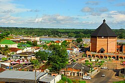
 City centre, Catedral Nossa Senhora da Glória, alongside Juruá River, Acre, Brazil. | |
| Nickname: Land of the Nahuas (Portuguese: Terra dos Nauas) | |
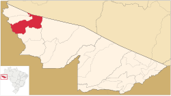
 Location in Acre | |
Location in Brazil | |
| Coordinates: 7°37′51″S 72°40′12″W / 7.63083°S 72.67000°W | |
| Country | |
| Region | North |
| State | |
| Founded | September 12, 1904 |
| Government | |
| • Mayor | Ilderlei Cordeiro (MDB) |
| Area | |
• Total | 7,924.943 km2 (3,059.838 sq mi) |
| Elevation | 182 m (597 ft) |
| Population (2020 est) | |
• Total | 89,072 |
| • Density | 8.94/km2 (23.2/sq mi) |
| Demonym | cruzeirense[1] |
| Time zone | UTC−5 (ACT) |
| CEP postal code | 69980-000 |
| Area code | +55 68 |
| HDI (2010) | 0.664 – medium[2] |
| Website | cruzeirodosul |
Cruzeiro do Sul (Portuguese pronunciation: [kɾuˈzejɾu du ˈsuw], Southern Cross) is a municipality located on the Juruá river in the west of the Brazilian state of Acre. It is the second-largest city in Acre.
It is bordered to the north by the state of Amazonas, to the south by Peru, to the east by the municipality of Porto Walter, to the west by the municipality of Rodrigues Alves, to the northwest by the municipality of Tarauacá, and to the northwest by the municipality of Mâncio Lima.
The municipality contains 23% of the 846,633 hectares (2,092,080 acres) Serra do Divisor National Park, created in 1989.[3]
- ^ "IBGE - Cidades". O Brasil Município por Município. Brazilian Institute of Geography and Statistics (IBGE). Retrieved 4 January 2021.
- ^ "Archived copy" (PDF). United Nations Development Programme (UNDP). Archived from the original (PDF) on July 8, 2014. Retrieved August 1, 2013.
{{cite web}}: CS1 maint: archived copy as title (link) - ^ PARNA da Serra do Divisor (in Portuguese), ISA: Instituto Socioambiental, retrieved 2016-08-08


