| Crystal Brook South Australia | |||||||||||||||
|---|---|---|---|---|---|---|---|---|---|---|---|---|---|---|---|
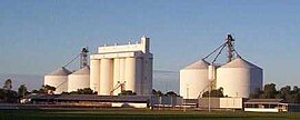
 The rising sun catching the Crystal Brook grain silos on a clear winter's morning; the town sports oval in the foreground | |||||||||||||||
| Coordinates | 33°21′0″S 138°12′0″E / 33.35000°S 138.20000°E | ||||||||||||||
| Population | 1,322 (UCL 2021)[1] | ||||||||||||||
| Established | 1873 | ||||||||||||||
| Postcode(s) | 5523 | ||||||||||||||
| Elevation | 115 m (377 ft)[2] | ||||||||||||||
| Location |
| ||||||||||||||
| LGA(s) | Port Pirie Regional Council | ||||||||||||||
| Region | Mid North | ||||||||||||||
| County | Southern Flinders Ranges | ||||||||||||||
| State electorate(s) | Frome | ||||||||||||||
| Federal division(s) | Grey | ||||||||||||||
| |||||||||||||||
| |||||||||||||||
Crystal Brook is a town in the Mid North of South Australia, 197 kilometres north of the capital, Adelaide. According to the 2021 Census, the population of the town was 1,322.[3] Crystal Brook is in a very picturesque location, being at the start of the Flinders Ranges. The town has multiple viewing points and parks. It was named after the spring-fed creek next to which it was founded.
Crystal Brook is the second largest town after the city of Port Pirie in the Southern Flinders Ranges area. The shady peppercorn trees grace the main street, Bowman Street. The area where the present town is now was founded in 1839 by Edward John Eyre who was passing through the region. He named it after the beautiful sparkling clear water and named it 'Chrystal Brook'.[4]
Crystal Brook is 197 kilometres (122 mi) north of Adelaide. The town has had some growth over the past year or two with more proposed job opportunities in the region. Crystal Brook is situated on Goyder's Line near the border of two climate systems. The township of Crystal Brook is surrounded by an intense farming region. As the town has experienced some growth in the past few years [when?] it has pushed housing development to the western side of the original township and across the creek.
The town benefits from a temperate mediterranean climate zone,[5] making possible slightly more intense farming in the region. To the south to south-east and west lies more intense farming and to the north-west lies some marginal, semi-arid farmland.
It is home to nearby Bowman Park, a nature preserve that is situated in the Crystal Brook Valley and has an abundance of wildlife and shady camping spots right next to the Crystal Brook Creek. The park contains history that dated back to the 1800s. The original homestead that belonged to the Bowman Brothers, which the park was named after, is there overlooking the Crystal Brook.
Summers in Crystal Brook are warm to hot and can be mostly dry . Winters are wet and cold with day time temps reaching just average 13 degrees Celsius or less and night time temps around 5 degrees Celsius. Many days are overcast and drizzle.
- ^ Australian Bureau of Statistics (28 June 2022). "Crystal Brook (urban centre and locality)". Australian Census 2021.
- ^ South Australian Rail Public timetable 1963, pg3
- ^ "2016 Census QuickStats: 5523, SA". quickstats.censusdata.abs.gov.au. Retrieved 13 April 2021.
- ^ Smart, Liz (27 August 2019). "Crystal Brook, SA". Aussie Towns. Retrieved 15 January 2020.
- ^ The Köppen climate classification system classifies the north of the Crystal Brook region as BSk, or cold semi-arid, and the bordering region to the east as Csb, or temperate mediterranean
