This article includes a list of general references, but it lacks sufficient corresponding inline citations. (April 2012) |
| Crystal Springs Dam | |
|---|---|
 | |
| Official name | Lower Crystal Springs Dam |
| Location | San Mateo County, California |
| Coordinates | 37°31′43″N 122°21′44″W / 37.5285°N 122.3622°W |
| Opening date | 1888 |
| Operator(s) | San Francisco Public Utilities Commission |
| Dam and spillways | |
| Impounds | San Mateo Creek |
| Height | 140 ft (43 m) |
| Length | 600 ft (180 m) |
| Width (base) | 40 ft (12 m) |
| Reservoir | |
| Creates | Lower Crystal Springs Reservoir |
| Total capacity | 57,910 acre⋅ft (71,430,000 m3) |
| Catchment area | 29.4 sq mi (76 km2) |
| Surface area | 1,323 acres (5.35 km2) |
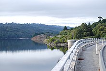
Crystal Springs Dam is a gravity dam constructed across the San Mateo Creek which is in San Mateo County, California. It impounds water to form the Lower Crystal Springs Reservoir which sits atop the San Andreas Fault in a rift valley created by the fault. The dam itself is located about 300 yards (273 meters) east of the fault.[1][2] It was among the first concrete gravity dams built in the western United States.[3] Skyline Boulevard runs over the dam, which also forms the trailhead of the popular Sawyer Camp Trail.
- ^ San Andreas Bay Area Faults
- ^ San Mateo Ezrim
- ^ Advanced Dam Engineering for Design, Construction, and Rehabilitation, by Robert B. Jansen, page 117