Culverden | |
|---|---|
town | |
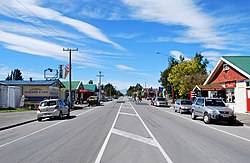
 Mountainview Road (New Zealand State Highway 7) in Culverden | |
 | |
| Coordinates: 42°46′S 172°51′E / 42.767°S 172.850°E | |
| Country | New Zealand |
| Region | Canterbury |
| Territorial authority | Hurunui District |
| Ward | West Ward |
| Electorates | |
| Government | |
| • Territorial Authority | Hurunui District Council |
| • Regional council | Environment Canterbury |
| • Mayor of Hurunui | Marie Black |
| • Kaikōura MP | Stuart Smith |
| • Te Tai Tonga MP | Tākuta Ferris |
| Area | |
• Total | 1.04 km2 (0.40 sq mi) |
| Elevation | 179 m (587 ft) |
| Population (June 2024)[2] | |
• Total | 380 |
| • Density | 370/km2 (950/sq mi) |
| Time zone | UTC+12 (New Zealand Standard Time) |
| • Summer (DST) | UTC+13 (New Zealand Daylight Time) |
| Postcode | 7392 |
| Area code | 03 |
| Local iwi | Ngāi Tahu |
Culverden is a small town in the northern Canterbury region of New Zealand's South Island. It lies at the centre of the Amuri Plain. Culverden has traditionally been surrounded by sheep farms. Dairy farms have now become more common as a result of irrigation schemes in the area. The Waiau Plains Irrigation Scheme was completed in 1980. It provides irrigation to 17,000 hectares of farmland and the Balmoral Scheme provides irrigation to a further 5500 hectares.[3]
The Health Department encouraged the Amuri County Council to install a water supply in Culverden as a result of a "slight epidemic" of hepatitis which was traced back to contaminated water. A town water supply was built in 1965.[3]
Rubbish collection began in Culverden in 1972. A proposal to provide Culverden with a sewage scheme in 1983 was approved by the Amuri County Council. Residents were unhappy with the cost of it and it was never built. Culverden was still without a sewage scheme in 2000. Culverden had its telephone exchange upgraded to an automatic exchange in 1984. The Bank of New Zealand closed its branch in Culverden in 1988. [3]
The Rutherford Reserve and the Culverden Recreation Reserve are on the southern side of Culverden and the Culverden Golf Course in on the northern entrance to Culverden. There is a memorial in the Rutherford Reserve to Dr Charles Little who died in November 1918 from the Spanish Flu. He was the county doctor providing medical services from Waikari to Waiau.[4]
- ^ Cite error: The named reference
Areawas invoked but never defined (see the help page). - ^ "Aotearoa Data Explorer". Statistics New Zealand. Retrieved 26 October 2024.
- ^ a b c Lovell-Smith, Margaret (2000). Hurunui Heritage The Development of a district 1950-2000. New Zealand: Hurunui District Council. pp. 74, 111–130. ISBN 0-473-07135-5.
- ^ "Dr Charles Little". my.christchurchcitylibraries.com. Retrieved 8 October 2020.