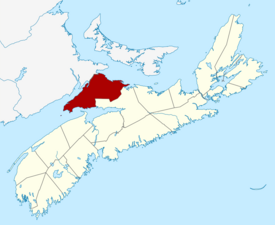
Cumberland County
Kwesomalegek (Mi'kmaq) | |
|---|---|
| Municipality of the County of Cumberland | |
 Location of Cumberland County, Nova Scotia | |
| Coordinates: 45°42′N 64°06′W / 45.7°N 64.1°W | |
| Country | Canada |
| Province | Nova Scotia |
| Towns | Amherst / Oxford |
| Established | August 17, 1759 |
| Incorporated | April 17, 1879 |
| Named for | Prince William, Duke of Cumberland |
| Electoral Districts Federal | Cumberland—Colchester |
| Provincial | Cumberland North / Cumberland South |
| Government | |
| • Type | Cumberland County Municipal Council |
| • Mayor | Rod Gilroy |
| • MLA | Elizabeth Smith-McCrossin (Independent) Tory Rushton (PCNS) |
| • MP | Stephen Ellis (CPC) |
| Area | |
| • Land | 4,275.77 km2 (1,650.88 sq mi) |
| Population | |
| • Total | 30,538 |
| • Density | 7.1/km2 (18/sq mi) |
| • Change 2011-16 | |
| Time zone | UTC-4 (AST) |
| • Summer (DST) | UTC-3 (ADT) |
| Area code | 902 |
| Dwellings | 18,445 |
| Median Income* | $38,433 CAD |
| Website | www.cumberland county.ns.ca |
| |
Cumberland County is a county in the Canadian province of Nova Scotia.
Cumberland was named in 1755 in honour of the Duke of Cumberland to replace Beausejour. The historic county was founded in 1759 when the English system of administration was installed to complement settlement during the Charles Lawrence governorship, and was later divided at the partitioning of the province and in 1840. The area thrived in the 19th century with the development of lumbering, shipbuilding, and coal mining, but rural outmigration and deforestation led to some communities being abandoned in the 20th century. The county spans an area of 4,271.23 km2 making it Nova Scotia's second largest county, with resources including extensive forest land, several mineral resources, and agricultural areas that concentrate on wild blueberry harvesting. As of the 2021 census, Cumberland County had a population of 30,538, with the majority residing in the Municipality of the County of Cumberland. The county includes two towns, Amherst and Oxford, and two large population centres, Parrsboro and Springhill.
- ^ a b "Community Profiles from the 2006 Census, Statistics Canada - Census Division". February 9, 2022.
- ^ [1] Population and dwelling counts, for Canada and census subdivisions (municipalities), 2006 and 2001 censuses - 100% data
