| Cumberland Narrows | |
|---|---|
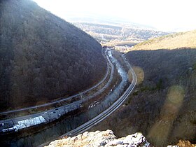
 The Cumberland Narrows west of Cumberland, Maryland, along Wills Creek, with Haystack Mountain on the left and Wills Mountain on the right. The Western Maryland Scenic Railroad (left), Alternate U.S. 40, the Old National Road (center, left of the creek), and the CSX Railroad (right) can be seen in the foreground. | |
| Elevation | 620 ft (189 m) |
| Traversed by | U.S. Route 40, the National Road |
| Location | Allegany County, Maryland, U.S. |
| Range | Ridge-and-Valley Appalachians |
| Coordinates | 39°40′05″N 78°47′07″W / 39.668075°N 78.785276°W |
| Topo map | USGS Cumberland |
The Cumberland Narrows (or simply The Narrows[1]) is a water gap in western Maryland in the United States, just west of Cumberland. Wills Creek cuts through the central ridge of the Wills Mountain Anticline at a low elevation here between Wills Mountain to the north and Haystack Mountain to the south. Cliffs and talus of the two mountains' Tuscarora quartzite caprock are prominent within the Narrows. A prominent rocky outcropping at the south end of Wills Mountain in the Cumberland Narrows is known as Lover's Leap.
The geological features of the Narrows provide Cumberland a western backdrop of the two mountains with a narrow gap between them.
- ^ "GNIS Detail - The Narrows". geonames.usgs.gov. Retrieved 2021-05-09.