| Cumulus | |
|---|---|
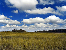
 Small cumulus humilis clouds that can have noticeable vertical development and clearly defined edges. | |
| Abbreviation | Cu |
| Symbol | |
| Genus | Cumulus (heap) |
| Species | |
| Variety |
|
| Altitude | 200–2,000 m (1,000–6,600 ft) |
| Classification | Family C (Low-level) |
| Appearance | Low-altitude, fluffy heaps of clouds with cotton-like appearance. |
| Precipitation | Uncommon rain, snow, or snow pellets |
Cumulus clouds are clouds that have flat bases and are often described as puffy, cotton-like, or fluffy in appearance. Their name derives from the Latin cumulus, meaning "heap" or "pile".[1] Cumulus clouds are low-level clouds, generally less than 2,000 m (6,600 ft) in altitude unless they are the more vertical cumulus congestus form. Cumulus clouds may appear by themselves, in lines, or in clusters.
Cumulus clouds are often precursors of other types of clouds, such as cumulonimbus, when influenced by weather factors such as instability, humidity, and temperature gradient. Normally, cumulus clouds produce little or no precipitation, but they can grow into the precipitation-bearing cumulus congestus or cumulonimbus clouds. Cumulus clouds can be formed from water vapour, supercooled water droplets, or ice crystals, depending upon the ambient temperature. They come in many distinct subforms and generally cool the earth by reflecting the incoming solar radiation.
Cumulus clouds are part of the larger category of free-convective cumuliform clouds, which include cumulonimbus clouds. The latter genus-type is sometimes categorized separately as cumulonimbiform due to its more complex structure that often includes a cirriform or anvil top.[2] There are also cumuliform clouds of limited convection that comprise stratocumulus (low-étage), altocumulus (middle-étage) and cirrocumulus (high-étage).[3] These last three genus-types are sometimes classified separately as stratocumuliform.[2]
- ^ Cite error: The named reference
CRH-NOAAwas invoked but never defined (see the help page). - ^ a b Barrett, E. C.; Grant, C. K. (1976). "The identification of cloud types in LANDSAT MSS images". NASA. Archived from the original on 2013-10-05. Retrieved 2012-08-22.
- ^ Geerts, B. (April 2000). "Cumuliform Clouds: Some Examples". Resources in Atmospheric Sciences. University of Wyoming College of Atmospheric Sciences. Retrieved 2013-02-11.