Cupang | |
|---|---|
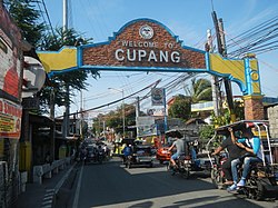
 Cupang welcome arch at Manuel L. Quezon Street | |
 | |
| Coordinates: 14°25′53.4″N 121°2′55″E / 14.431500°N 121.04861°E | |
| Country | Philippines |
| Region | National Capital Region |
| City | Muntinlupa |
| District | 2nd Legislative district of Muntinlupa |
| Government | |
| • Type | Barangay |
| • Barangay Captain | Luvi Constantino |
| Area | |
• Total | 5.370 km2 (2.073 sq mi) |
| Population (2020)[1] | |
• Total | 57,196 |
| • Density | 11,000/km2 (28,000/sq mi) |
| Time zone | UTC+8 (PST) |
| Postal Code | 1773 |
| Area code | 02 |
| Range | Marikina Valley Fault Ridge |
Cupang is a barangay in Muntinlupa, Metro Manila, Philippines.[2] The total land area of the barangay is 5.370 km2 (2.073 sq mi). It has a population of 57,196 as of the 2020 census. It is located in the northern section of the city.
Cupang is located south of the City of Manila. It is bounded on the north by the Muntinlupa barangay of Buli, on the south by the Muntinlupa barangays of Alabang and Ayala Alabang, on the west by the Parañaque barangay of BF Homes and the Las Piñas barangay of Almanza Uno, and on the east by Laguna de Bay.
- ^ Census of Population (2020). "National Capital Region (NCR)". Total Population by Province, City, Municipality and Barangay. Philippine Statistics Authority. Retrieved 8 July 2021.
- ^ "Brgy. Cupang – City Government of Muntinlupa". muntinlupacity.gov.ph. Philippines: Government of the Philippines. Retrieved 2019-01-06.