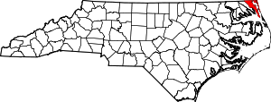
Currituck County | |
|---|---|
 Currituck County Courthouse | |
 Location within the U.S. state of North Carolina | |
 North Carolina's location within the U.S. | |
| Coordinates: 36°22′N 75°56′W / 36.37°N 75.94°W | |
| Country | |
| State | |
| Founded | 1668 |
| Named for | Algonquin term meaning "The Land of the Wild Geese"[1] |
| Seat | Currituck |
| Largest community | Moyock |
| Area | |
• Total | 526.43 sq mi (1,363.4 km2) |
| • Land | 261.91 sq mi (678.3 km2) |
| • Water | 264.52 sq mi (685.1 km2) 50.25% |
| Population (2020) | |
• Total | 28,100 |
• Estimate (2023) | 31,593 |
| • Density | 107.29/sq mi (41.42/km2) |
| Time zone | UTC−5 (Eastern) |
| • Summer (DST) | UTC−4 (EDT) |
| Congressional district | 3rd |
| Website | www |
Currituck County (/ˈkʊrɪtʌk/)[2] is the northeasternmost county in the U.S. state of North Carolina. As of the 2020 census, the population was 28,100.[3] Its county seat is Currituck.[4] The county was formed in 1668 as a precinct of Albemarle County and later gained county status in 1739.[5] The name is "traditionally said to be an indigenous word for wild geese; Coratank." Currituck County is included in the Virginia Beach-Chesapeake, VA-NC Combined Statistical Area.[6] It is in the northeastern section of the state and is bounded by the Atlantic Ocean, Currituck Sound, Camden County, Dare County and the Commonwealth of Virginia. Currituck Court House, mentioned as early as 1755, was the name of the county seat. Today the words "Court House" have been dropped and only Currituck is used as the community name.
- ^ Mazzocchi, Jay (2006). Powell, William S. (ed.). "Currituck County". NCpedia. University of North Carolina Press. Retrieved September 9, 2023.
- ^ Talk Like A Tarheel Archived June 22, 2013, at the Wayback Machine, from the North Carolina Collection's website at the University of North Carolina at Chapel Hill. Retrieved February 5, 2013.
- ^ Cite error: The named reference
2020CensusQuickFactswas invoked but never defined (see the help page). - ^ "Find a County". National Association of Counties. Archived from the original on May 31, 2011. Retrieved June 7, 2011.
- ^ "North Carolina: Individual County Chronologies". North Carolina Atlas of Historical County Boundaries. The Newberry Library. 2009. Archived from the original on March 4, 2016. Retrieved January 22, 2015.
- ^ "OMB Bulletin No. 23-01: Revised Delineations of Metropolitan Statistical Areas, Micropolitan Statistical Areas, and Combined Statistical Areas, and Guidance on Uses of the Delineations of These Areas" (PDF). United States Office of Management and Budget. July 21, 2023. Retrieved August 10, 2023.

