Cut Bank | |
|---|---|
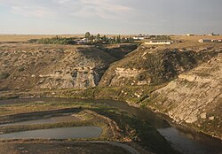
 Housing along Cut Bank Creek | |
 Location of Cut Bank, Montana | |
| Coordinates: 48°38′5″N 112°19′52″W / 48.63472°N 112.33111°W | |
| Country | United States |
| State | Montana |
| County | Glacier |
| Area | |
• Total | 1.16 sq mi (3.01 km2) |
| • Land | 1.16 sq mi (3.00 km2) |
| • Water | 0.00 sq mi (0.01 km2) |
| Elevation | 3,773 ft (1,150 m) |
| Population (2020) | |
• Total | 3,056 |
| • Density | 2,641.31/sq mi (1,020.07/km2) |
| Time zone | UTC−7 (Mountain (MST)) |
| • Summer (DST) | UTC−6 (MDT) |
| ZIP code | 59427 |
| Area code | 406 |
| FIPS code | 30-18775 |
| GNIS feature ID | 0770395 |
| Website | cityofcutbank |
Cut Bank is a city in and the county seat of Glacier County, Montana, United States, located just east of the "cut bank" (gorge) along Cut Bank Creek.[2] The population was 3,056 at the 2020 census,[3] The town began in 1891 with the arrival of the Great Northern Railway.[4]
- ^ "ArcGIS REST Services Directory". United States Census Bureau. Retrieved September 5, 2022.
- ^ "Find a County". National Association of Counties. Archived from the original on May 31, 2011. Retrieved June 7, 2011.
- ^ "U.S. Census website". United States Census Bureau. Retrieved November 2, 2021.
- ^ "Cut Bank". Montana Place Names Companion. Montana Historical Society. Retrieved April 2, 2021.