Cuyahoga County Airport Robert D. Shea Field | |||||||||||
|---|---|---|---|---|---|---|---|---|---|---|---|
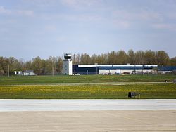
 Control tower at KCGF | |||||||||||
 Airport diagram | |||||||||||
| Summary | |||||||||||
| Airport type | Public | ||||||||||
| Owner/Operator | Cuyahoga County | ||||||||||
| Serves | Cleveland, Ohio | ||||||||||
| Location | Highland Heights Richmond Heights Willoughby Hills | ||||||||||
| Time zone | UTC−05:00 (-5) | ||||||||||
| • Summer (DST) | UTC−04:00 (-4) | ||||||||||
| Elevation AMSL | 879 ft / 268 m | ||||||||||
| Coordinates | 41°33′54″N 081°29′11″W / 41.56500°N 81.48639°W | ||||||||||
| Website | CuyahogaCounty.us/... | ||||||||||
| Map | |||||||||||
 | |||||||||||
| Runways | |||||||||||
| |||||||||||
| Statistics (2020) | |||||||||||
| |||||||||||
Cuyahoga County Airport (IATA: CGF[2], ICAO: KCGF, FAA LID: CGF), also known as Robert D. Shea Field,[3] is a public use airport in northeastern Cuyahoga County, Ohio, United States.[1] Owned and operated by Cuyahoga County since 1946,[3] it also serves Lake County and Geauga County. The airport is located 10 nautical miles (12 mi, 19 km) east of downtown Cleveland[1] and sits on the border of three cities: Highland Heights, Richmond Heights and Willoughby Hills.[3] It is included in the National Plan of Integrated Airport Systems for 2011–2015, which categorized it as a general aviation reliever airport[4] for Cleveland Hopkins International Airport.
- ^ a b c FAA Airport Form 5010 for CGF PDF. Federal Aviation Administration. effective November 15, 2012.
- ^ "IATA Airport Code Search (CLE: Cleveland / Cuyahoga County)". International Air Transport Association. Retrieved December 19, 2012.
- ^ a b c Cite error: The named reference
Airportwas invoked but never defined (see the help page). - ^ "2011–2015 NPIAS Report, Appendix A" (PDF). National Plan of Integrated Airport Systems. Federal Aviation Administration. October 4, 2010. Archived from the original (PDF, 2.03 MB) on 2012-09-27.

