Cyrville | |
|---|---|
Neighbourhood | |
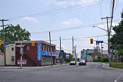
 Historic centre of Cyrville at the intersection of Cyrville and Ogilvie Roads | |
| Coordinates: 45°25′29″N 75°38′03″W / 45.42472°N 75.63417°W | |
| Country | Canada |
| Province | Ontario |
| City | Ottawa |
| Founding | 1853 |
| Government | |
| • MPs | Mona Fortier, David McGuinty |
| • MPPs | Lucille Collard, John Fraser |
| • Councillors | Tim Tierney |
| Area | |
• Total | 2.517 km2 (0.972 sq mi) |
| Elevation | 70 m (230 ft) |
| Population | |
• Total | 4,513 |
| • Density | 1,800/km2 (4,600/sq mi) |
| Time zone | Eastern (EST) |
| Forward sortation areas | K1B, K1J |
Cyrville (also referred to as Cummings) is a neighbourhood in Beacon Hill-Cyrville Ward in the east-end of Ottawa, Ontario, Canada.[1] The area is located within the former City of Gloucester, and is roughly bounded on the north, west and south by the former Gloucester City limit, and on the east by the Aviation Parkway and Highway 417. Once a francophone farming village, the area now a mix of residential and industrial land, being home to the Cyrville Industrial Area. It has been described as a "tangle of freeways and utility corridors".[2] It has a population of 4513 (2016 census), 280 of which live south of the Queensway.[3]
- ^ "Cyrville". Geographical Names Data Base. Natural Resources Canada. Retrieved 2014-02-06.
- ^ "Cyrville cradles the heart of Gloucester". Ottawa Citizen. October 12, 2000.
- ^ Population can be calculated by combining Census Tract 5050122.01 with Dissemination area 35061667 and block 35061308021
